Tiefenbach geodata
Tiefenbach (Bavaria) is a seat of a fourth-order administrative division; located in Germany in Europe/Berlin (GMT+2) time zone. With population of 3,501 people, there are 3613 cities with bigger population in this country. Compared to other cities in Germany, 89.2% of cities are located further ↑North; 83.2% of cities are located further ←West and 79.5% of cities have lower elevation than Tiefenbach. Note1
Administrative division(s):
- Level 1: Bavaria
- Level 2: Lower Bavaria
- Level 3: Landkreis Landshut
- Level 4: Tiefenbach


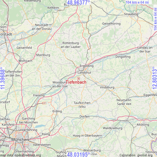
Tiefenbach GPS coordinates[2]
48° 30' 0" North, 12° 6' 0" East
| Map corner | latitude | longitude |
|---|---|---|
| Upper-left | 48.96377°, | 11.39688° |
| Center: | 48.5°, | 12.1° |
| Lower-right: | 48.03195°, | 12.80313° |
| Map W x H: | 103.6×103.6 km | = 64.4×64.4mi |
| max Lat: | 55.01917° ⇑89.2% North |
| Tiefenbach: | 48.5° |
| min Lat: | ⇓10.8% South 47.40724° |
| min Long | Tiefenbach | max Long |
| 5.92978° | 12.1° | 14.98853° |
| W 83.2%⇐ | ⇒16.8% E |
Elevation
Elevation of Tiefenbach is 430 m = 1411 ft, and this is 180.9 m = 594 ft above average elevation for this country.
| Max E: |
1256 m = 4121 ft | 20.5% |
| Tiefenbach | 430 m 1411 ft | |
| Avg. | 249.1 m = 817 ft | |
Min E: |
-5 m = -16 ft | 79.5% |
See also: Germany elevation on elevation.city.
Geographical zone
Tiefenbach is located in North temperate zone (between Tropic of Cancer and the Arctic Circle). Distance of this North polar circle is 2008.5 km =1248 mi to North.| Distance of | km | miles | from Tiefenbach |
|---|---|---|---|
| North Pole | 4614.4 | 2867.3 | to North |
| Arctic Circle | 2008.5 | 1248 | to North |
| Tropic Cancer | 2786.8 | 1731.6 | to South |
| Equator | 5392.7 | 3350.9 | to South |


Nearby cities:
15 places around Tiefenbach: (largest is in red/bold)
• Altfraunhofen
7.4 km =4.6 mi,  138°
138°
• Baierbach
11.8 km =7.3 mi, 141°
• Bruckberg
8.2 km =5.1 mi,  287°
287°
• Eching
2.5 km =1.6 mi,  270°
270°
• Eging
7.8 km =4.8 mi,  121°
121°
• Ergolding
10 km =6.2 mi,  31°
31°
• Furth
11.7 km =7.3 mi,  329°
329°
• Geisenhausen
12 km =7.5 mi,  102°
102°
• Kirchberg
11.7 km =7.3 mi,  198°
198°
• Kumhausen
4.3 km =2.7 mi,  75°
75°
• Landshut
5.6 km =3.5 mi,  54°
54°
• Stallwang
11.6 km =7.2 mi,  56°
56°
• Vilsheim
5.7 km =3.5 mi,  174°
174°
• Wang
12.1 km =7.5 mi, 267°
• Weihmichl
11.7 km =7.3 mi,  341°
341°
Sources, notices
• [Note1] Compared only with cities in Germany existing in our database
• [Src1] Map data: © OpenStreetMap contributors (CC-BY-SA)
• [Src2] Other city data from geonames.org with taken over terms of usage.
• [Src3] Geographical zone / Annual Mean Temperature by Robert A. Rohde @ Wikipedia
