Eching geodata
Eching (Bavaria) is a seat of a fourth-order administrative division; located in Germany in Europe/Berlin (GMT+2) time zone. With population of 3,516 people, there are 3599 cities with bigger population in this country. Compared to other cities in Germany, 89.2% of cities are located further ↑North; 82.7% of cities are located further ←West and 79% of cities have lower elevation than Eching. Note1
Administrative division(s):
- Level 1: Bavaria
- Level 2: Lower Bavaria
- Level 3: Landkreis Landshut
- Level 4: Eching


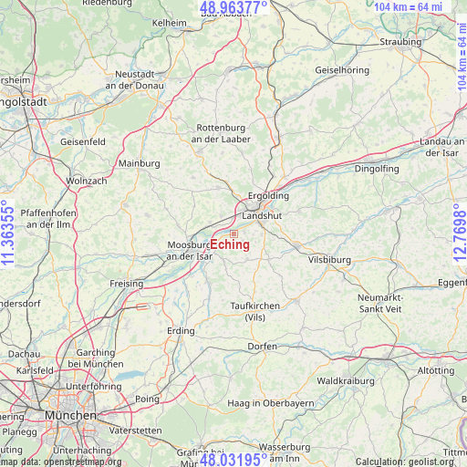
Eching GPS coordinates[2]
48° 30' 0" North, 12° 4' 0.012" East
| Map corner | latitude | longitude |
|---|---|---|
| Upper-left | 48.96377°, | 11.36355° |
| Center: | 48.5°, | 12.06667° |
| Lower-right: | 48.03195°, | 12.7698° |
| Map W x H: | 103.6×103.6 km | = 64.4×64.4mi |
| max Lat: | 55.01917° ⇑89.2% North |
| Eching: | 48.5° |
| min Lat: | ⇓10.8% South 47.40724° |
| min Long | Eching | max Long |
| 5.92978° | 12.06667° | 14.98853° |
| W 82.7%⇐ | ⇒17.3% E |
Elevation
Elevation of Eching is 427 m = 1401 ft, and this is 177.9 m = 584 ft above average elevation for this country.
| Max E: |
1256 m = 4121 ft | 21% |
| Eching | 427 m 1401 ft | |
| Avg. | 249.1 m = 817 ft | |
Min E: |
-5 m = -16 ft | 79% |
See also: Germany elevation on elevation.city.
Geographical zone
Eching is located in North temperate zone (between Tropic of Cancer and the Arctic Circle). Distance of this North polar circle is 2008.5 km =1248 mi to North.| Distance of | km | miles | from Eching |
|---|---|---|---|
| North Pole | 4614.4 | 2867.3 | to North |
| Arctic Circle | 2008.5 | 1248 | to North |
| Tropic Cancer | 2786.8 | 1731.6 | to South |
| Equator | 5392.7 | 3350.9 | to South |


Nearby cities:
15 places around Eching: (largest is in red/bold)
• Altfraunhofen
9.2 km =5.7 mi,  127°
127°
• Bruckberg
5.9 km =3.7 mi,  295°
295°
• Eging
9.9 km =6.2 mi,  114°
114°
• Ergolding
11.5 km =7.1 mi,  42°
42°
• Furth
10.7 km =6.6 mi,  341°
341°
• Gammelsdorf
10.2 km =6.3 mi, 302°
• Kirchberg
11.2 km =7 mi,  186°
186°
• Kumhausen
6.7 km =4.2 mi,  81°
81°
• Landshut
7.7 km =4.8 mi,  64°
64°
• Langenpreising
10.8 km =6.7 mi,  220°
220°
• Moosburg
10 km =6.2 mi,  251°
251°
• Tiefenbach
2.5 km =1.6 mi,  90°
90°
• Vilsheim
6.4 km =4 mi,  152°
152°
• Wang
9.6 km =6 mi,  267°
267°
• Weihmichl
11.2 km =7 mi,  353°
353°
Sources, notices
• [Note1] Compared only with cities in Germany existing in our database
• [Src1] Map data: © OpenStreetMap contributors (CC-BY-SA)
• [Src2] Other city data from geonames.org with taken over terms of usage.
• [Src3] Geographical zone / Annual Mean Temperature by Robert A. Rohde @ Wikipedia
