Gaimersheim geodata
Gaimersheim (Bavaria) is a populated place; located in Germany in Europe/Berlin (GMT+2) time zone. With population of 10,840 people, there are 1523 cities with bigger population in this country. Compared to other cities in Germany, 85.3% of cities are located further ↑North; 72.3% of cities are located further ←West and 73.2% of cities have lower elevation than Gaimersheim. Note1
Administrative division(s):
- Level 1: Bavaria
- Level 2: Upper Bavaria
- Level 3: Landkreis Eichstätt
- Level 4: Gaimersheim, Markt


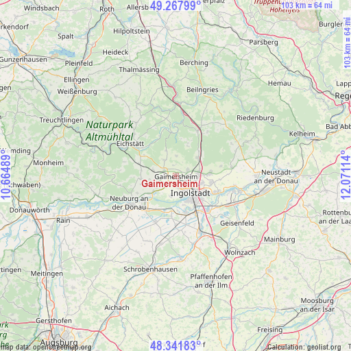
Gaimersheim GPS coordinates[2]
48° 48' 25.38" North, 11° 22' 4.836" East
| Map corner | latitude | longitude |
|---|---|---|
| Upper-left | 49.26799°, | 10.66489° |
| Center: | 48.80705°, | 11.36801° |
| Lower-right: | 48.34183°, | 12.07114° |
| Map W x H: | 103×103 km | = 64×64mi |
| max Lat: | 55.01917° ⇑85.3% North |
| Gaimersheim: | 48.80705° |
| min Lat: | ⇓14.7% South 47.40724° |
| min Long | Gaimersheim | max Long |
| 5.92978° | 11.36801° | 14.98853° |
| W 72.3%⇐ | ⇒27.7% E |
Elevation
Elevation of Gaimersheim is 384 m = 1260 ft, and this is 134.9 m = 443 ft above average elevation for this country.
| Max E: |
1256 m = 4121 ft | 26.8% |
| Gaimersheim | 384 m 1260 ft | |
| Avg. | 249.1 m = 817 ft | |
Min E: |
-5 m = -16 ft | 73.2% |
See also: Germany elevation on elevation.city.
Geographical zone
Gaimersheim is located in North temperate zone (between Tropic of Cancer and the Arctic Circle). Distance of this North polar circle is 1974.3 km =1226.8 mi to North.| Distance of | km | miles | from Gaimersheim |
|---|---|---|---|
| North Pole | 4580.2 | 2846 | to North |
| Arctic Circle | 1974.3 | 1226.8 | to North |
| Tropic Cancer | 2820.9 | 1752.8 | to South |
| Equator | 5426.8 | 3372.1 | to South |


Nearby cities:
15 places around Gaimersheim: (largest is in red/bold)
• Adelschlag
11.5 km =7.1 mi,  288°
288°
• Bergheim
9.6 km =6 mi,  237°
237°
• Buxheim
5.6 km =3.5 mi,  269°
269°
• Böhmfeld
6 km =3.7 mi,  359°
359°
• Egweil
10.2 km =6.3 mi,  255°
255°
• Eitensheim
3.9 km =2.4 mi, 285°
• Großmehring
12.9 km =8 mi,  110°
110°
• Hepberg
7.1 km =4.4 mi,  75°
75°
• Hitzhofen
6.1 km =3.8 mi,  321°
321°
• Ingolstadt
6.2 km =3.9 mi,  138°
138°
• Lenting
6.6 km =4.1 mi,  86°
86°
• Stammham
8.4 km =5.2 mi,  49°
49°
• Walting
13.2 km =8.2 mi,  337°
337°
• Weichering
10.6 km =6.6 mi,  198°
198°
• Wettstetten
3.8 km =2.4 mi,  63°
63°
Sources, notices
• [Note1] Compared only with cities in Germany existing in our database
• [Src1] Map data: © OpenStreetMap contributors (CC-BY-SA)
• [Src2] Other city data from geonames.org with taken over terms of usage.
• [Src3] Geographical zone / Annual Mean Temperature by Robert A. Rohde @ Wikipedia
