Bergheim geodata
Bergheim (Bavaria) is a seat of a fourth-order administrative division; located in Germany in Europe/Berlin (GMT+2) time zone. In our database, there are 11009 cities with bigger population. Compared to other cities in Germany, 85.8% of cities are located further ↑North; 70.8% of cities are located further ←West and 74.3% of cities have lower elevation than Bergheim. Note1
Administrative division(s):
- Level 1: Bavaria
- Level 2: Upper Bavaria
- Level 3: Landkreis Neuburg-Schrobenhausen
- Level 4: Bergheim


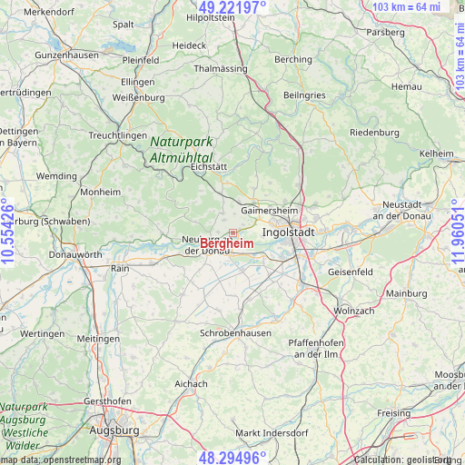
Bergheim GPS coordinates[2]
48° 45' 38.16" North, 11° 15' 26.568" East
| Map corner | latitude | longitude |
|---|---|---|
| Upper-left | 49.22197°, | 10.55426° |
| Center: | 48.7606°, | 11.25738° |
| Lower-right: | 48.29496°, | 11.96051° |
| Map W x H: | 103.1×103.1 km | = 64.1×64.1mi |
| max Lat: | 55.01917° ⇑85.8% North |
| Bergheim: | 48.7606° |
| min Lat: | ⇓14.2% South 47.40724° |
| min Long | Bergheim | max Long |
| 5.92978° | 11.25738° | 14.98853° |
| W 70.8%⇐ | ⇒29.2% E |
Elevation
Elevation of Bergheim is 392 m = 1286 ft, and this is 142.9 m = 469 ft above average elevation for this country.
| Max E: |
1256 m = 4121 ft | 25.7% |
| Bergheim | 392 m 1286 ft | |
| Avg. | 249.1 m = 817 ft | |
Min E: |
-5 m = -16 ft | 74.3% |
See also: Germany elevation on elevation.city.
Geographical zone
Bergheim is located in North temperate zone (between Tropic of Cancer and the Arctic Circle). Distance of this North polar circle is 1979.5 km =1230 mi to North.| Distance of | km | miles | from Bergheim |
|---|---|---|---|
| North Pole | 4585.4 | 2849.2 | to North |
| Arctic Circle | 1979.5 | 1230 | to North |
| Tropic Cancer | 2815.8 | 1749.7 | to South |
| Equator | 5421.7 | 3368.9 | to South |


Nearby cities:
15 places around Bergheim: (largest is in red/bold)
• Adelschlag
9.3 km =5.8 mi,  342°
342°
• Berg im Gau
14.2 km =8.8 mi,  182°
182°
• Buxheim
5.7 km =3.5 mi,  26°
26°
• Böhmfeld
13.8 km =8.6 mi,  36°
36°
• Egweil
3.1 km =1.9 mi,  325°
325°
• Eitensheim
7.6 km =4.7 mi, 34°
• Gaimersheim
9.6 km =6 mi,  57°
57°
• Hitzhofen
10.8 km =6.7 mi,  23°
23°
• Ingolstadt
12.2 km =7.6 mi,  87°
87°
• Karlshuld
9 km =5.6 mi,  166°
166°
• Neuburg an der Donau
6 km =3.7 mi,  238°
238°
• Oberhausen
11.5 km =7.1 mi,  248°
248°
• Rohrenfels
11.1 km =6.9 mi,  222°
222°
• Weichering
6.7 km =4.2 mi,  135°
135°
• Wettstetten
13.4 km =8.3 mi, 59°
Sources, notices
• [Note1] Compared only with cities in Germany existing in our database
• [Src1] Map data: © OpenStreetMap contributors (CC-BY-SA)
• [Src2] Other city data from geonames.org with taken over terms of usage.
• [Src3] Geographical zone / Annual Mean Temperature by Robert A. Rohde @ Wikipedia
