Friedland geodata
Friedland (Mecklenburg-Vorpommern) is a populated place; located in Germany in Europe/Berlin (GMT+2) time zone. With population of 6,966 people, there are 2192 cities with bigger population in this country. Compared to other cities in Germany, 88.1% of cities are located further ↓South; 96.1% of cities are located further ←West and 92% of cities have higher elevation than Friedland. Note1
Administrative division(s):
- Level 1: Mecklenburg-Vorpommern
- Level 3: Mecklenburgische Seenplatte
- Level 4: Friedland


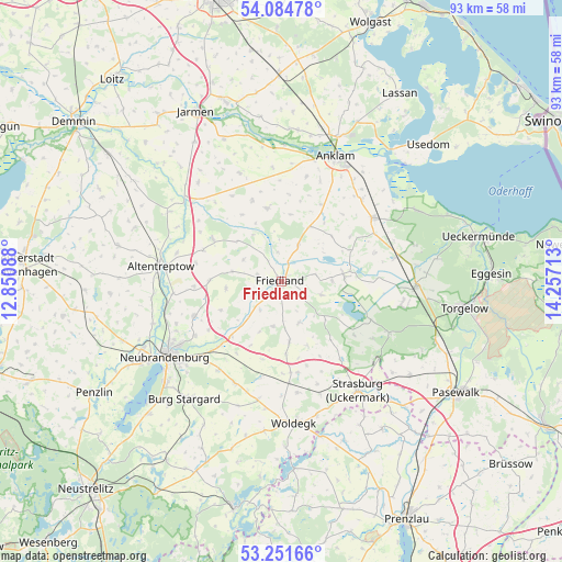
Friedland GPS coordinates[2]
53° 40' 13.008" North, 13° 33' 14.4" East
| Map corner | latitude | longitude |
|---|---|---|
| Upper-left | 54.08478°, | 12.85088° |
| Center: | 53.67028°, | 13.554° |
| Lower-right: | 53.25166°, | 14.25713° |
| Map W x H: | 92.6×92.6 km | = 57.5×57.5mi |
| max Lat: | 55.01917° ⇑11.9% North |
| Friedland: | 53.67028° |
| min Lat: | ⇓88.1% South 47.40724° |
| min Long | Friedland | max Long |
| 5.92978° | 13.554° | 14.98853° |
| W 96.1%⇐ | ⇒3.9% E |
Elevation
Elevation of Friedland is 16 m = 52 ft, and this is 233.1 m = 765 ft below average elevation for this country.
| Max E: |
1256 m = 4121 ft | 92% |
| Avg. | 249.1 m = 817 ft | |
| Friedland | 16 m = 52 ft | |
Min E: |
-5 m = -16 ft | 8% |
See also: Germany elevation on elevation.city.
Geographical zone
Friedland is located in North temperate zone (between Tropic of Cancer and the Arctic Circle). Distance of this North polar circle is 1433.6 km =890.8 mi to North.| Distance of | km | miles | from Friedland |
|---|---|---|---|
| North Pole | 4039.5 | 2510 | to North |
| Arctic Circle | 1433.6 | 890.8 | to North |
| Tropic Cancer | 3361.7 | 2088.9 | to South |
| Equator | 5967.6 | 3708.1 | to South |


Nearby cities:
15 places around Friedland: (largest is in red/bold)
• Alt-Sanitz
16.1 km =10 mi,  7°
7°
• Boldekow
6.6 km =4.1 mi,  23°
23°
• Brunn
12.1 km =7.5 mi,  270°
270°
• Eichhorst
9.2 km =5.7 mi,  203°
203°
• Groß Miltzow
15.2 km =9.4 mi,  170°
170°
• Heinrichswalde
16.1 km =10 mi,  113°
113°
• Kessin
17.5 km =10.9 mi,  292°
292°
• Neuenkirchen
14.6 km =9.1 mi,  236°
236°
• Neverin
15.4 km =9.6 mi,  248°
248°
• Pragsdorf
18 km =11.2 mi,  215°
215°
• Rossow
12.9 km =8 mi,  256°
256°
• Schönbeck
9.9 km =6.2 mi, 173°
• Siedenbollentin
13.3 km =8.3 mi,  301°
301°
• Spantekow
12.2 km =7.6 mi,  348°
348°
• Staven
11 km =6.8 mi, 244°
Sources, notices
• [Note1] Compared only with cities in Germany existing in our database
• [Src1] Map data: © OpenStreetMap contributors (CC-BY-SA)
• [Src2] Other city data from geonames.org with taken over terms of usage.
• [Src3] Geographical zone / Annual Mean Temperature by Robert A. Rohde @ Wikipedia
