Staven geodata
Staven (Mecklenburg-Vorpommern) is a populated place; located in Germany in Europe/Berlin (GMT+2) time zone. With population of 560 people, there are 9028 cities with bigger population in this country. Compared to other cities in Germany, 87.4% of cities are located further ↓South; 95.2% of cities are located further ←West and 76.1% of cities have higher elevation than Staven. Note1
Administrative division(s):
- Level 1: Mecklenburg-Vorpommern
- Level 3: Mecklenburgische Seenplatte
- Level 4: Staven


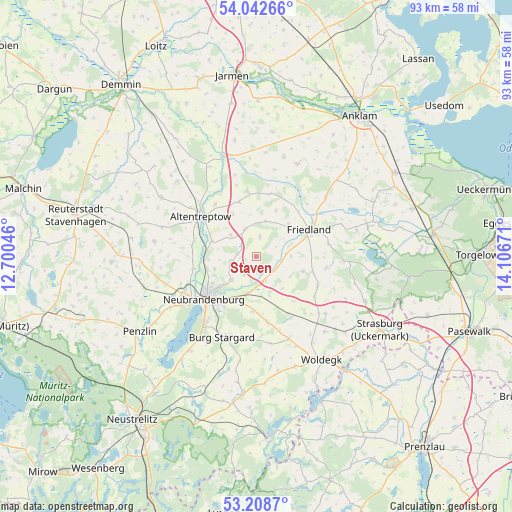
Staven GPS coordinates[2]
53° 37' 39.864" North, 13° 24' 12.888" East
| Map corner | latitude | longitude |
|---|---|---|
| Upper-left | 54.04266°, | 12.70046° |
| Center: | 53.62774°, | 13.40358° |
| Lower-right: | 53.2087°, | 14.10671° |
| Map W x H: | 92.7×92.7 km | = 57.6×57.6mi |
| max Lat: | 55.01917° ⇑12.6% North |
| Staven: | 53.62774° |
| min Lat: | ⇓87.4% South 47.40724° |
| min Long | Staven | max Long |
| 5.92978° | 13.40358° | 14.98853° |
| W 95.2%⇐ | ⇒4.8% E |
Elevation
Elevation of Staven is 59 m = 194 ft, and this is 190.1 m = 624 ft below average elevation for this country.
| Max E: |
1256 m = 4121 ft | 76.1% |
| Avg. | 249.1 m = 817 ft | |
| Staven | 59 m = 194 ft | |
Min E: |
-5 m = -16 ft | 23.9% |
See also: Germany elevation on elevation.city.
Geographical zone
Staven is located in North temperate zone (between Tropic of Cancer and the Arctic Circle). Distance of this North polar circle is 1438.3 km =893.7 mi to North.| Distance of | km | miles | from Staven |
|---|---|---|---|
| North Pole | 4044.2 | 2512.9 | to North |
| Arctic Circle | 1438.3 | 893.7 | to North |
| Tropic Cancer | 3356.9 | 2085.9 | to South |
| Equator | 5962.8 | 3705.1 | to South |


Nearby cities:
15 places around Staven: (largest is in red/bold)
• Altentreptow
11.7 km =7.3 mi,  308°
308°
• Brunn
5.3 km =3.3 mi,  335°
335°
• Cölpin
12 km =7.5 mi,  170°
170°
• Eichhorst
7.2 km =4.5 mi,  120°
120°
• Friedland
11 km =6.8 mi,  64°
64°
• Groß Teetzleben
11.7 km =7.3 mi,  279°
279°
• Neubrandenburg
11 km =6.8 mi,  230°
230°
• Neuenkirchen
4.1 km =2.5 mi,  213°
213°
• Neverin
4.5 km =2.8 mi,  259°
259°
• Pragsdorf
9.9 km =6.2 mi,  183°
183°
• Rossow
3.1 km =1.9 mi,  302°
302°
• Schönbeck
12.2 km =7.6 mi,  114°
114°
• Siedenbollentin
11.8 km =7.3 mi,  352°
352°
• Trollenhagen
7.8 km =4.8 mi,  252°
252°
• Woggersin
11.6 km =7.2 mi, 259°
Sources, notices
• [Note1] Compared only with cities in Germany existing in our database
• [Src1] Map data: © OpenStreetMap contributors (CC-BY-SA)
• [Src2] Other city data from geonames.org with taken over terms of usage.
• [Src3] Geographical zone / Annual Mean Temperature by Robert A. Rohde @ Wikipedia
