Neverin geodata
Neverin (Mecklenburg-Vorpommern) is a populated place; located in Germany in Europe/Berlin (GMT+2) time zone. With population of 1,179 people, there are 6620 cities with bigger population in this country. Compared to other cities in Germany, 87.3% of cities are located further ↓South; 94.6% of cities are located further ←West and 74.5% of cities have higher elevation than Neverin. Note1
Administrative division(s):
- Level 1: Mecklenburg-Vorpommern
- Level 3: Mecklenburgische Seenplatte
- Level 4: Neverin


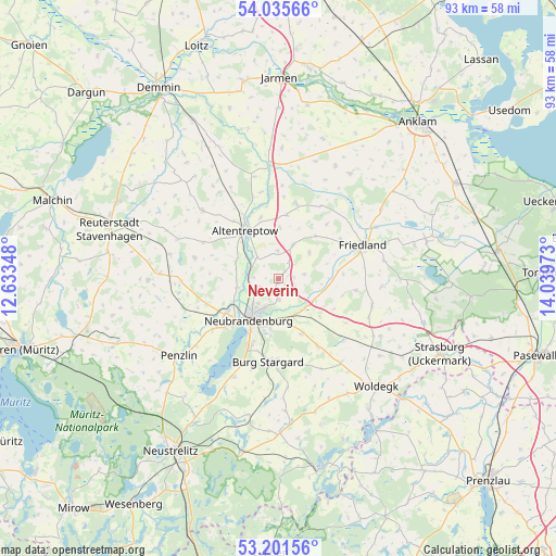
Neverin GPS coordinates[2]
53° 37' 14.412" North, 13° 20' 11.76" East
| Map corner | latitude | longitude |
|---|---|---|
| Upper-left | 54.03566°, | 12.63348° |
| Center: | 53.62067°, | 13.3366° |
| Lower-right: | 53.20156°, | 14.03973° |
| Map W x H: | 92.7×92.7 km | = 57.6×57.6mi |
| max Lat: | 55.01917° ⇑12.7% North |
| Neverin: | 53.62067° |
| min Lat: | ⇓87.3% South 47.40724° |
| min Long | Neverin | max Long |
| 5.92978° | 13.3366° | 14.98853° |
| W 94.6%⇐ | ⇒5.4% E |
Elevation
Elevation of Neverin is 65 m = 213 ft, and this is 184.1 m = 604 ft below average elevation for this country.
| Max E: |
1256 m = 4121 ft | 74.5% |
| Avg. | 249.1 m = 817 ft | |
| Neverin | 65 m = 213 ft | |
Min E: |
-5 m = -16 ft | 25.5% |
See also: Germany elevation on elevation.city.
Geographical zone
Neverin is located in North temperate zone (between Tropic of Cancer and the Arctic Circle). Distance of this North polar circle is 1439.1 km =894.2 mi to North.| Distance of | km | miles | from Neverin |
|---|---|---|---|
| North Pole | 4045 | 2513.4 | to North |
| Arctic Circle | 1439.1 | 894.2 | to North |
| Tropic Cancer | 3356.1 | 2085.4 | to South |
| Equator | 5962.1 | 3704.7 | to South |


Nearby cities:
15 places around Neverin: (largest is in red/bold)
• Altentreptow
9.4 km =5.8 mi,  330°
330°
• Breesen
11.3 km =7 mi,  275°
275°
• Brunn
6 km =3.7 mi,  21°
21°
• Cölpin
12.8 km =8 mi,  149°
149°
• Eichhorst
11 km =6.8 mi,  105°
105°
• Groß Teetzleben
7.7 km =4.8 mi,  290°
290°
• Kessin
12.2 km =7.6 mi,  351°
351°
• Neubrandenburg
7.5 km =4.7 mi,  212°
212°
• Neuenkirchen
3.4 km =2.1 mi,  140°
140°
• Pragsdorf
9.9 km =6.2 mi,  157°
157°
• Rossow
3 km =1.9 mi,  35°
35°
• Siedenbollentin
12.8 km =8 mi,  13°
13°
• Staven
4.5 km =2.8 mi,  79°
79°
• Trollenhagen
3.4 km =2.1 mi,  243°
243°
• Woggersin
7.1 km =4.4 mi,  258°
258°
Sources, notices
• [Note1] Compared only with cities in Germany existing in our database
• [Src1] Map data: © OpenStreetMap contributors (CC-BY-SA)
• [Src2] Other city data from geonames.org with taken over terms of usage.
• [Src3] Geographical zone / Annual Mean Temperature by Robert A. Rohde @ Wikipedia
