Pragsdorf geodata
Pragsdorf (Mecklenburg-Vorpommern) is a populated place; located in Germany in Europe/Berlin (GMT+2) time zone. With population of 548 people, there are 9089 cities with bigger population in this country. Compared to other cities in Germany, 86% of cities are located further ↓South; 95% of cities are located further ←West and 75.5% of cities have higher elevation than Pragsdorf. Note1
Administrative division(s):
- Level 1: Mecklenburg-Vorpommern
- Level 3: Mecklenburgische Seenplatte
- Level 4: Pragsdorf


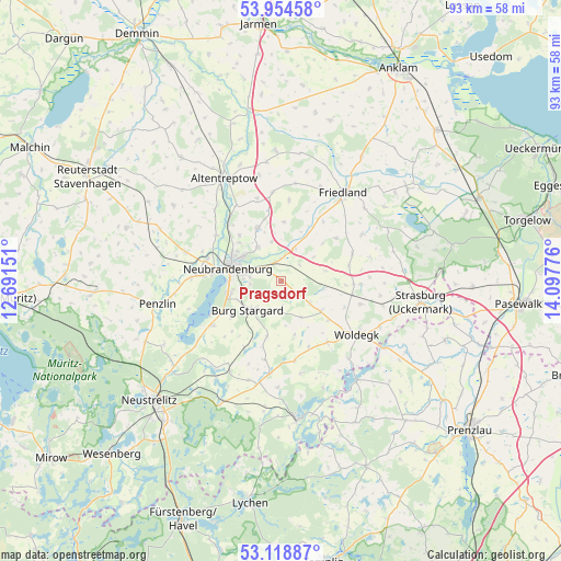
Pragsdorf GPS coordinates[2]
53° 32' 19.644" North, 13° 23' 40.668" East
| Map corner | latitude | longitude |
|---|---|---|
| Upper-left | 53.95458°, | 12.69151° |
| Center: | 53.53879°, | 13.39463° |
| Lower-right: | 53.11887°, | 14.09776° |
| Map W x H: | 92.9×92.9 km | = 57.7×57.7mi |
| max Lat: | 55.01917° ⇑14% North |
| Pragsdorf: | 53.53879° |
| min Lat: | ⇓86% South 47.40724° |
| min Long | Pragsdorf | max Long |
| 5.92978° | 13.39463° | 14.98853° |
| W 95%⇐ | ⇒5% E |
Elevation
Elevation of Pragsdorf is 61 m = 200 ft, and this is 188.1 m = 617 ft below average elevation for this country.
| Max E: |
1256 m = 4121 ft | 75.5% |
| Avg. | 249.1 m = 817 ft | |
| Pragsdorf | 61 m = 200 ft | |
Min E: |
-5 m = -16 ft | 24.5% |
See also: Germany elevation on elevation.city.
Geographical zone
Pragsdorf is located in North temperate zone (between Tropic of Cancer and the Arctic Circle). Distance of this North polar circle is 1448.2 km =899.9 mi to North.| Distance of | km | miles | from Pragsdorf |
|---|---|---|---|
| North Pole | 4054.1 | 2519.1 | to North |
| Arctic Circle | 1448.2 | 899.9 | to North |
| Tropic Cancer | 3347 | 2079.7 | to South |
| Equator | 5953 | 3699 | to South |


Nearby cities:
15 places around Pragsdorf: (largest is in red/bold)
• Burg Stargard
7.3 km =4.5 mi,  229°
229°
• Cölpin
3.3 km =2.1 mi,  126°
126°
• Eichhorst
9.2 km =5.7 mi,  47°
47°
• Groß Miltzow
13.1 km =8.1 mi,  91°
91°
• Holldorf
11.5 km =7.1 mi,  224°
224°
• Loitz
10.8 km =6.7 mi,  182°
182°
• Neubrandenburg
8.4 km =5.2 mi,  289°
289°
• Neuenkirchen
6.7 km =4.2 mi,  345°
345°
• Neverin
9.9 km =6.2 mi,  337°
337°
• Rossow
11.7 km =7.3 mi, 349°
• Schönbeck
12.7 km =7.9 mi,  67°
67°
• Staven
9.9 km =6.2 mi,  3°
3°
• Teschendorf
9.3 km =5.8 mi,  195°
195°
• Trollenhagen
10.2 km =6.3 mi,  317°
317°
• Woggersin
13.3 km =8.3 mi,  305°
305°
Sources, notices
• [Note1] Compared only with cities in Germany existing in our database
• [Src1] Map data: © OpenStreetMap contributors (CC-BY-SA)
• [Src2] Other city data from geonames.org with taken over terms of usage.
• [Src3] Geographical zone / Annual Mean Temperature by Robert A. Rohde @ Wikipedia
