Friedenfels geodata
Friedenfels (Bavaria) is a seat of a fourth-order administrative division; located in Germany in Europe/Berlin (GMT+2) time zone. With population of 1,352 people, there are 6177 cities with bigger population in this country. Compared to other cities in Germany, 67% of cities are located further ↑North; 83.2% of cities are located further ←West and 90.7% of cities have lower elevation than Friedenfels. Note1
Administrative division(s):
- Level 1: Bavaria
- Level 2: Upper Palatinate
- Level 3: Landkreis Tirschenreuth
- Level 4: Friedenfels


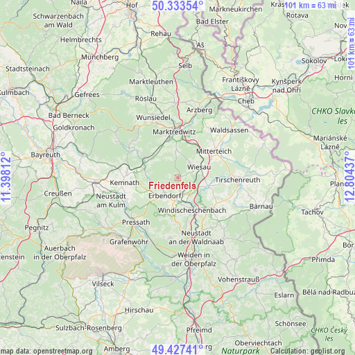
Friedenfels GPS coordinates[2]
49° 52' 57.36" North, 12° 6' 4.464" East
| Map corner | latitude | longitude |
|---|---|---|
| Upper-left | 50.33354°, | 11.39812° |
| Center: | 49.8826°, | 12.10124° |
| Lower-right: | 49.42741°, | 12.80437° |
| Map W x H: | 100.8×100.8 km | = 62.6×62.6mi |
| max Lat: | 55.01917° ⇑67% North |
| Friedenfels: | 49.8826° |
| min Lat: | ⇓33% South 47.40724° |
| min Long | Friedenfels | max Long |
| 5.92978° | 12.10124° | 14.98853° |
| W 83.2%⇐ | ⇒16.8% E |
Elevation
Elevation of Friedenfels is 523 m = 1716 ft, and this is 273.9 m = 899 ft above average elevation for this country.
| Max E: |
1256 m = 4121 ft | 9.3% |
| Friedenfels | 523 m 1716 ft | |
| Avg. | 249.1 m = 817 ft | |
Min E: |
-5 m = -16 ft | 90.7% |
See also: Germany elevation on elevation.city.
Geographical zone
Friedenfels is located in North temperate zone (between Tropic of Cancer and the Arctic Circle). Distance of this North polar circle is 1854.7 km =1152.5 mi to North.| Distance of | km | miles | from Friedenfels |
|---|---|---|---|
| North Pole | 4460.6 | 2771.7 | to North |
| Arctic Circle | 1854.7 | 1152.5 | to North |
| Tropic Cancer | 2940.5 | 1827.1 | to South |
| Equator | 5546.4 | 3446.4 | to South |


Nearby cities:
15 places around Friedenfels: (largest is in red/bold)
• Berg
8.1 km =5 mi,  159°
159°
• Ebnath
14.2 km =8.8 mi,  301°
301°
• Erbendorf
6.2 km =3.9 mi,  219°
219°
• Falkenberg
9.4 km =5.8 mi,  106°
106°
• Fuchsmühl
5.5 km =3.4 mi,  35°
35°
• Kirchendemenreuth
11 km =6.8 mi,  180°
180°
• Krummennaab
5.5 km =3.4 mi, 180°
• Marktredwitz
13.6 km =8.5 mi,  355°
355°
• Mitterteich
12.7 km =7.9 mi,  52°
52°
• Neusorg
11.2 km =7 mi, 300°
• Pechbrunn
10.5 km =6.5 mi,  26°
26°
• Pullenreuth
9.2 km =5.7 mi,  307°
307°
• Waldershof
11.3 km =7 mi,  345°
345°
• Wiesau
6.9 km =4.3 mi,  65°
65°
• Windischeschenbach
9.9 km =6.2 mi, 156°
Sources, notices
• [Note1] Compared only with cities in Germany existing in our database
• [Src1] Map data: © OpenStreetMap contributors (CC-BY-SA)
• [Src2] Other city data from geonames.org with taken over terms of usage.
• [Src3] Geographical zone / Annual Mean Temperature by Robert A. Rohde @ Wikipedia
