Freyburg geodata
Freyburg (Saxony-Anhalt) is a populated place; located in Germany in Europe/Berlin (GMT+2) time zone. With population of 4,451 people, there are 3061 cities with bigger population in this country. Compared to other cities in Germany, 61.7% of cities are located further ↓South; 78.3% of cities are located further ←West and 65.6% of cities have higher elevation than Freyburg. Note1
Administrative division(s):
- Level 1: Saxony-Anhalt
- Level 3: Burgenlandkreis
- Level 4: Freyburg (Unstrut)


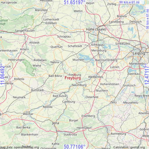
Freyburg GPS coordinates[2]
51° 12' 49.032" North, 11° 46' 4.944" East
| Map corner | latitude | longitude |
|---|---|---|
| Upper-left | 51.65197°, | 11.06492° |
| Center: | 51.21362°, | 11.76804° |
| Lower-right: | 50.77106°, | 12.47117° |
| Map W x H: | 97.9×97.9 km | = 60.8×60.8mi |
| max Lat: | 55.01917° ⇑38.3% North |
| Freyburg: | 51.21362° |
| min Lat: | ⇓61.7% South 47.40724° |
| min Long | Freyburg | max Long |
| 5.92978° | 11.76804° | 14.98853° |
| W 78.3%⇐ | ⇒21.7% E |
Elevation
Elevation of Freyburg is 117 m = 384 ft, and this is 132.1 m = 433 ft below average elevation for this country.
| Max E: |
1256 m = 4121 ft | 65.6% |
| Avg. | 249.1 m = 817 ft | |
| Freyburg | 117 m = 384 ft | |
Min E: |
-5 m = -16 ft | 34.4% |
See also: Germany elevation on elevation.city.
Geographical zone
Freyburg is located in North temperate zone (between Tropic of Cancer and the Arctic Circle). Distance of this North polar circle is 1706.8 km =1060.6 mi to North.| Distance of | km | miles | from Freyburg |
|---|---|---|---|
| North Pole | 4312.6 | 2679.7 | to North |
| Arctic Circle | 1706.8 | 1060.6 | to North |
| Tropic Cancer | 3088.5 | 1919.1 | to South |
| Equator | 5694.4 | 3538.3 | to South |


Nearby cities:
15 places around Freyburg: (largest is in red/bold)
• Bad Kösen
9.4 km =5.8 mi,  199°
199°
• Balgstädt
2.6 km =1.6 mi,  249°
249°
• Burgscheidungen
9.6 km =6 mi,  292°
292°
• Gleina
6 km =3.7 mi,  326°
326°
• Goseck
7 km =4.3 mi,  102°
102°
• Gröst
7.6 km =4.7 mi,  47°
47°
• Karsdorf
10 km =6.2 mi,  309°
309°
• Krumpa
10.7 km =6.6 mi,  29°
29°
• Laucha
6.3 km =3.9 mi,  280°
280°
• Leißling
10.4 km =6.5 mi,  109°
109°
• Mücheln
9.7 km =6 mi,  16°
16°
• Naumburg
7.7 km =4.8 mi,  157°
157°
• Schönburg
8.6 km =5.3 mi,  127°
127°
• Uichteritz
10.8 km =6.7 mi,  94°
94°
• Wethau
10.5 km =6.5 mi,  143°
143°
Sources, notices
• [Note1] Compared only with cities in Germany existing in our database
• [Src1] Map data: © OpenStreetMap contributors (CC-BY-SA)
• [Src2] Other city data from geonames.org with taken over terms of usage.
• [Src3] Geographical zone / Annual Mean Temperature by Robert A. Rohde @ Wikipedia
