Naumburg geodata
Naumburg (Saxony-Anhalt) is a seat of a third-order administrative division; located in Germany in Europe/Berlin (GMT+2) time zone. With population of 29,722 people, there are 471 cities with bigger population in this country. Compared to other cities in Germany, 60.7% of cities are located further ↓South; 79% of cities are located further ←West and 62.7% of cities have higher elevation than Naumburg. Note1
Administrative division(s):
- Level 1: Saxony-Anhalt
- Level 3: Burgenlandkreis
- Level 4: Naumburg (Saale)


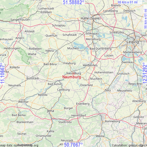
Naumburg GPS coordinates[2]
51° 8' 59.532" North, 11° 48' 35.244" East
| Map corner | latitude | longitude |
|---|---|---|
| Upper-left | 51.58882°, | 11.10667° |
| Center: | 51.14987°, | 11.80979° |
| Lower-right: | 50.7067°, | 12.51292° |
| Map W x H: | 98.1×98.1 km | = 61×61mi |
| max Lat: | 55.01917° ⇑39.3% North |
| Naumburg: | 51.14987° |
| min Lat: | ⇓60.7% South 47.40724° |
| min Long | Naumburg | max Long |
| 5.92978° | 11.80979° | 14.98853° |
| W 79%⇐ | ⇒21% E |
Elevation
Elevation of Naumburg is 134 m = 440 ft, and this is 115.1 m = 378 ft below average elevation for this country.
| Max E: |
1256 m = 4121 ft | 62.7% |
| Avg. | 249.1 m = 817 ft | |
| Naumburg | 134 m = 440 ft | |
Min E: |
-5 m = -16 ft | 37.3% |
See also: Germany elevation on elevation.city.
Geographical zone
Naumburg is located in North temperate zone (between Tropic of Cancer and the Arctic Circle). Distance of this North polar circle is 1713.8 km =1064.9 mi to North.| Distance of | km | miles | from Naumburg |
|---|---|---|---|
| North Pole | 4319.7 | 2684.1 | to North |
| Arctic Circle | 1713.8 | 1064.9 | to North |
| Tropic Cancer | 3081.4 | 1914.7 | to South |
| Equator | 5687.3 | 3533.9 | to South |


Nearby cities:
15 places around Naumburg: (largest is in red/bold)
• Bad Kösen
6.4 km =4 mi,  254°
254°
• Balgstädt
8.1 km =5 mi,  319°
319°
• Freyburg
7.7 km =4.8 mi,  337°
337°
• Goseck
6.8 km =4.2 mi,  35°
35°
• Gröbitz
8.2 km =5.1 mi,  101°
101°
• Görschen
7.7 km =4.8 mi,  123°
123°
• Leißling
7.8 km =4.8 mi,  62°
62°
• Lengefeld
7.8 km =4.8 mi,  241°
241°
• Mertendorf
4.8 km =3 mi,  135°
135°
• Molau
10.5 km =6.5 mi,  191°
191°
• Prittitz
8.4 km =5.2 mi,  89°
89°
• Schönburg
4.4 km =2.7 mi, 64°
• Stößen
8.9 km =5.5 mi, 116°
• Uichteritz
10.1 km =6.3 mi,  51°
51°
• Wethau
3.6 km =2.2 mi,  113°
113°
Sources, notices
• [Note1] Compared only with cities in Germany existing in our database
• [Src1] Map data: © OpenStreetMap contributors (CC-BY-SA)
• [Src2] Other city data from geonames.org with taken over terms of usage.
• [Src3] Geographical zone / Annual Mean Temperature by Robert A. Rohde @ Wikipedia
