Mücheln geodata
Mücheln (Saxony-Anhalt) is a populated place; located in Germany in Europe/Berlin (GMT+2) time zone. With population of 6,389 people, there are 2336 cities with bigger population in this country. Compared to other cities in Germany, 63.2% of cities are located further ↓South; 78.9% of cities are located further ←West and 56.2% of cities have higher elevation than Mücheln. Note1


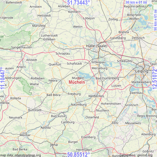
Mücheln GPS coordinates[2]
51° 17' 48.768" North, 11° 48' 27.324" East
| Map corner | latitude | longitude |
|---|---|---|
| Upper-left | 51.73443°, | 11.10447° |
| Center: | 51.29688°, | 11.80759° |
| Lower-right: | 50.85512°, | 12.51072° |
| Map W x H: | 97.8×97.8 km | = 60.8×60.8mi |
| max Lat: | 55.01917° ⇑36.8% North |
| Mücheln: | 51.29688° |
| min Lat: | ⇓63.2% South 47.40724° |
| min Long | Mücheln | max Long |
| 5.92978° | 11.80759° | 14.98853° |
| W 78.9%⇐ | ⇒21.1% E |
Elevation
Elevation of Mücheln is 180 m = 591 ft, and this is 69.1 m = 227 ft below average elevation for this country.
| Max E: |
1256 m = 4121 ft | 56.2% |
| Avg. | 249.1 m = 817 ft | |
| Mücheln | 180 m = 591 ft | |
Min E: |
-5 m = -16 ft | 43.8% |
See also: Germany elevation on elevation.city.
Geographical zone
Mücheln is located in North temperate zone (between Tropic of Cancer and the Arctic Circle). Distance of this North polar circle is 1697.5 km =1054.8 mi to North.| Distance of | km | miles | from Mücheln |
|---|---|---|---|
| North Pole | 4303.4 | 2674 | to North |
| Arctic Circle | 1697.5 | 1054.8 | to North |
| Tropic Cancer | 3097.8 | 1924.9 | to South |
| Equator | 5703.7 | 3544.1 | to South |


Nearby cities:
15 places around Mücheln: (largest is in red/bold)
• Beuna
10.1 km =6.3 mi,  77°
77°
• Braunsbedra
5.8 km =3.6 mi,  101°
101°
• Frankleben
8.6 km =5.3 mi, 79°
• Freyburg
9.7 km =6 mi,  196°
196°
• Geusa
10.6 km =6.6 mi,  63°
63°
• Gleina
7.5 km =4.7 mi,  234°
234°
• Großkayna
8.7 km =5.4 mi,  94°
94°
• Gröst
5 km =3.1 mi,  144°
144°
• Klobikau
6.2 km =3.9 mi,  16°
16°
• Krumpa
2.5 km =1.6 mi, 89°
• Langeneichstädt
7 km =4.3 mi,  320°
320°
• Milzau
10.8 km =6.7 mi,  36°
36°
• Schafstädt
9.7 km =6 mi,  345°
345°
• Steigra
9.8 km =6.1 mi,  272°
272°
• Öchlitz
4.3 km =2.7 mi,  313°
313°
Sources, notices
• [Note1] Compared only with cities in Germany existing in our database
• [Src1] Map data: © OpenStreetMap contributors (CC-BY-SA)
• [Src2] Other city data from geonames.org with taken over terms of usage.
• [Src3] Geographical zone / Annual Mean Temperature by Robert A. Rohde @ Wikipedia
