Kreuztal geodata
Kreuztal (North Rhine-Westphalia) is a populated place; located in Germany in Europe/Berlin (GMT+2) time zone. With population of 31,772 people, there are 436 cities with bigger population in this country. Compared to other cities in Germany, 57.6% of cities are located further ↓South; 77.3% of cities are located further →East and 67.1% of cities have lower elevation than Kreuztal. Note1
Administrative division(s):
- Level 1: North Rhine-Westphalia
- Level 2: Regierungsbezirk Arnsberg
- Level 3: Kreis Siegen-Wittgenstein
- Level 4: Kreuztal


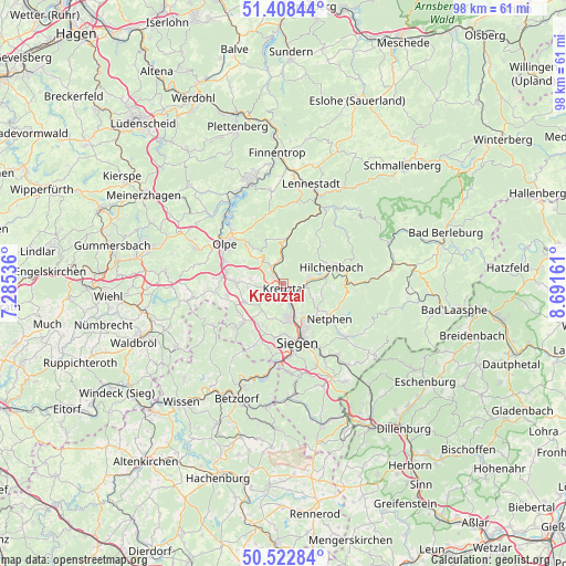
Kreuztal GPS coordinates[2]
50° 58' 3.9" North, 7° 59' 18.528" East
| Map corner | latitude | longitude |
|---|---|---|
| Upper-left | 51.40844°, | 7.28536° |
| Center: | 50.96775°, | 7.98848° |
| Lower-right: | 50.52284°, | 8.69161° |
| Map W x H: | 98.5×98.5 km | = 61.2×61.2mi |
| max Lat: | 55.01917° ⇑42.4% North |
| Kreuztal: | 50.96775° |
| min Lat: | ⇓57.6% South 47.40724° |
| min Long | Kreuztal | max Long |
| 5.92978° | 7.98848° | 14.98853° |
| W 22.7%⇐ | ⇒77.3% E |
Elevation
Elevation of Kreuztal is 336 m = 1102 ft, and this is 86.9 m = 285 ft above average elevation for this country.
| Max E: |
1256 m = 4121 ft | 32.9% |
| Kreuztal | 336 m 1102 ft | |
| Avg. | 249.1 m = 817 ft | |
Min E: |
-5 m = -16 ft | 67.1% |
See also: Germany elevation on elevation.city.
Geographical zone
Kreuztal is located in North temperate zone (between Tropic of Cancer and the Arctic Circle). Distance of this North polar circle is 1734.1 km =1077.5 mi to North.| Distance of | km | miles | from Kreuztal |
|---|---|---|---|
| North Pole | 4340 | 2696.8 | to North |
| Arctic Circle | 1734.1 | 1077.5 | to North |
| Tropic Cancer | 3061.2 | 1902.1 | to South |
| Equator | 5667.1 | 3521.4 | to South |


Nearby cities:
15 places around Kreuztal: (largest is in red/bold)
• Brachbach
17.2 km =10.7 mi,  192°
192°
• Drolshagen
16.3 km =10.1 mi,  292°
292°
• Freudenberg
11.2 km =7 mi,  225°
225°
• Friesenhagen
14.4 km =8.9 mi,  240°
240°
• Harbach
17 km =10.6 mi,  219°
219°
• Hilchenbach
9.1 km =5.7 mi,  69°
69°
• Kirchhundem
14.9 km =9.3 mi,  28°
28°
• Lennestadt
17.5 km =10.9 mi,  18°
18°
• Mudersbach
16.2 km =10.1 mi, 191°
• Netphen
9.7 km =6 mi,  126°
126°
• Niederfischbach
15.6 km =9.7 mi,  213°
213°
• Olpe
11.8 km =7.3 mi,  305°
305°
• Siegen
10.6 km =6.6 mi,  166°
166°
• Wenden
8.5 km =5.3 mi,  269°
269°
• Wilnsdorf
18.5 km =11.5 mi,  155°
155°
Sources, notices
• [Note1] Compared only with cities in Germany existing in our database
• [Src1] Map data: © OpenStreetMap contributors (CC-BY-SA)
• [Src2] Other city data from geonames.org with taken over terms of usage.
• [Src3] Geographical zone / Annual Mean Temperature by Robert A. Rohde @ Wikipedia
