Edelsfeld geodata
Edelsfeld (Bavaria) is a seat of a fourth-order administrative division; located in Germany in Europe/Berlin (GMT+2) time zone. With population of 2,012 people, there are 5053 cities with bigger population in this country. Compared to other cities in Germany, 74.3% of cities are located further ↑North; 77.1% of cities are located further ←West and 91.2% of cities have lower elevation than Edelsfeld. Note1
Administrative division(s):
- Level 1: Bavaria
- Level 2: Upper Palatinate
- Level 3: Landkreis Amberg-Sulzbach
- Level 4: Edelsfeld


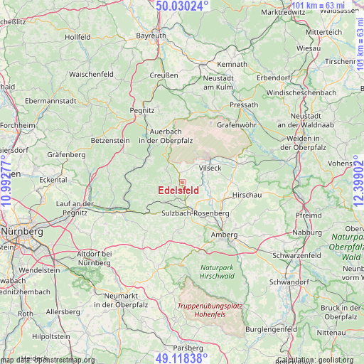
Edelsfeld GPS coordinates[2]
49° 34' 35.184" North, 11° 41' 45.204" East
| Map corner | latitude | longitude |
|---|---|---|
| Upper-left | 50.03024°, | 10.99277° |
| Center: | 49.57644°, | 11.69589° |
| Lower-right: | 49.11838°, | 12.39902° |
| Map W x H: | 101.4×101.4 km | = 63×63mi |
| max Lat: | 55.01917° ⇑74.3% North |
| Edelsfeld: | 49.57644° |
| min Lat: | ⇓25.7% South 47.40724° |
| min Long | Edelsfeld | max Long |
| 5.92978° | 11.69589° | 14.98853° |
| W 77.1%⇐ | ⇒22.9% E |
Elevation
Elevation of Edelsfeld is 531 m = 1742 ft, and this is 281.9 m = 925 ft above average elevation for this country.
| Max E: |
1256 m = 4121 ft | 8.8% |
| Edelsfeld | 531 m 1742 ft | |
| Avg. | 249.1 m = 817 ft | |
Min E: |
-5 m = -16 ft | 91.2% |
See also: Germany elevation on elevation.city.
Geographical zone
Edelsfeld is located in North temperate zone (between Tropic of Cancer and the Arctic Circle). Distance of this North polar circle is 1888.8 km =1173.6 mi to North.| Distance of | km | miles | from Edelsfeld |
|---|---|---|---|
| North Pole | 4494.7 | 2792.9 | to North |
| Arctic Circle | 1888.8 | 1173.6 | to North |
| Tropic Cancer | 2906.5 | 1806 | to South |
| Equator | 5512.4 | 3425.2 | to South |


Nearby cities:
15 places around Edelsfeld: (largest is in red/bold)
• Auerbach
13.6 km =8.5 mi,  340°
340°
• Etzelwang
9.6 km =6 mi,  235°
235°
• Gebenbach
13.4 km =8.3 mi,  108°
108°
• Hahnbach
9.1 km =5.7 mi,  121°
121°
• Hartenstein
13.2 km =8.2 mi,  281°
281°
• Hirschbach
12.1 km =7.5 mi,  255°
255°
• Illschwang
14.1 km =8.8 mi,  183°
183°
• Königstein
5.9 km =3.7 mi,  307°
307°
• Neuhaus an der Pegnitz
11.9 km =7.4 mi,  298°
298°
• Poppenricht
13.4 km =8.3 mi,  146°
146°
• Sulzbach-Rosenberg
9.1 km =5.7 mi,  156°
156°
• Velden
14 km =8.7 mi,  287°
287°
• Vilseck
8.8 km =5.5 mi,  60°
60°
• Vorra
14.7 km =9.1 mi, 261°
• Weigendorf
12.7 km =7.9 mi,  226°
226°
Sources, notices
• [Note1] Compared only with cities in Germany existing in our database
• [Src1] Map data: © OpenStreetMap contributors (CC-BY-SA)
• [Src2] Other city data from geonames.org with taken over terms of usage.
• [Src3] Geographical zone / Annual Mean Temperature by Robert A. Rohde @ Wikipedia
