Nieder-Ingelheim geodata
Nieder-Ingelheim (Rheinland-Pfalz) is a section of populated place; located in Germany in Europe/Berlin (GMT+2) time zone. With population of 24,596 people, there are 601 cities with bigger population in this country. Compared to other cities in Germany, 64.4% of cities are located further ↑North; 75.9% of cities are located further →East and 62.5% of cities have higher elevation than Nieder-Ingelheim. Note1
Administrative division(s):
- Level 1: Rheinland-Pfalz
- Level 3: Landkreis Mainz-Bingen
- Level 4: Ingelheim am Rhein


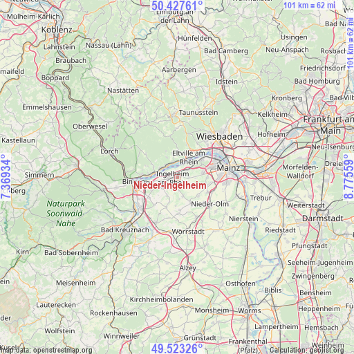
Nieder-Ingelheim GPS coordinates[2]
49° 58' 39.216" North, 8° 4' 20.856" East
| Map corner | latitude | longitude |
|---|---|---|
| Upper-left | 50.42761°, | 7.36934° |
| Center: | 49.97756°, | 8.07246° |
| Lower-right: | 49.52326°, | 8.77559° |
| Map W x H: | 100.6×100.6 km | = 62.5×62.5mi |
| max Lat: | 55.01917° ⇑64.4% North |
| Nieder-Ingelheim: | 49.97756° |
| min Lat: | ⇓35.6% South 47.40724° |
| min Long | Nieder-Ingelhei | max Long |
| 5.92978° | 8.07246° | 14.98853° |
| W 24.1%⇐ | ⇒75.9% E |
Elevation
Elevation of Nieder-Ingelheim is 135 m = 443 ft, and this is 114.1 m = 374 ft below average elevation for this country.
| Max E: |
1256 m = 4121 ft | 62.5% |
| Avg. | 249.1 m = 817 ft | |
| Nieder-Ingelheim | 135 m = 443 ft | |
Min E: |
-5 m = -16 ft | 37.5% |
See also: Germany elevation on elevation.city.
Geographical zone
Nieder-Ingelheim is located in North temperate zone (between Tropic of Cancer and the Arctic Circle). Distance of this North polar circle is 1844.2 km =1145.9 mi to North.| Distance of | km | miles | from Nieder-Ingelheim |
|---|---|---|---|
| North Pole | 4450.1 | 2765.2 | to North |
| Arctic Circle | 1844.2 | 1145.9 | to North |
| Tropic Cancer | 2951.1 | 1833.7 | to South |
| Equator | 5557 | 3453 | to South |


Nearby cities:
15 places around Nieder-Ingelheim: (largest is in red/bold)
• Appenheim
6 km =3.7 mi,  207°
207°
• Bubenheim
6.2 km =3.9 mi,  175°
175°
• Budenheim
8 km =5 mi,  57°
57°
• Eltville
6.5 km =4 mi,  29°
29°
• Engelstadt
8.2 km =5.1 mi, 183°
• Essenheim
7.9 km =4.9 mi,  131°
131°
• Gau-Algesheim
4.7 km =2.9 mi,  240°
240°
• Geisenheim
7.5 km =4.7 mi,  276°
276°
• Ingelheim am Rhein
1.2 km =0.7 mi,  232°
232°
• Kiedrich
7 km =4.3 mi,  7°
7°
• Nieder-Hilbersheim
7.5 km =4.7 mi,  197°
197°
• Ockenheim
8.2 km =5.1 mi, 242°
• Schwabenheim
5.7 km =3.5 mi,  163°
163°
• Stadecken-Elsheim
8.2 km =5.1 mi,  152°
152°
• Wackernheim
3.2 km =2 mi,  96°
96°
Sources, notices
• [Note1] Compared only with cities in Germany existing in our database
• [Src1] Map data: © OpenStreetMap contributors (CC-BY-SA)
• [Src2] Other city data from geonames.org with taken over terms of usage.
• [Src3] Geographical zone / Annual Mean Temperature by Robert A. Rohde @ Wikipedia
