Essenbach geodata
Essenbach (Bavaria) is a populated place; located in Germany in Europe/Berlin (GMT+2) time zone. With population of 11,070 people, there are 1492 cities with bigger population in this country. Compared to other cities in Germany, 87.7% of cities are located further ↑North; 84.9% of cities are located further ←West and 74.2% of cities have lower elevation than Essenbach. Note1
Administrative division(s):
- Level 1: Bavaria
- Level 2: Lower Bavaria
- Level 3: Landkreis Landshut
- Level 4: Essenbach, Markt


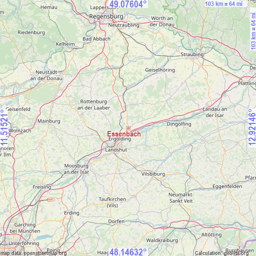
Essenbach GPS coordinates[2]
48° 36' 47.952" North, 12° 13' 5.988" East
| Map corner | latitude | longitude |
|---|---|---|
| Upper-left | 49.07604°, | 11.51521° |
| Center: | 48.61332°, | 12.21833° |
| Lower-right: | 48.14632°, | 12.92146° |
| Map W x H: | 103.4×103.4 km | = 64.2×64.2mi |
| max Lat: | 55.01917° ⇑87.7% North |
| Essenbach: | 48.61332° |
| min Lat: | ⇓12.3% South 47.40724° |
| min Long | Essenbach | max Long |
| 5.92978° | 12.21833° | 14.98853° |
| W 84.9%⇐ | ⇒15.1% E |
Elevation
Elevation of Essenbach is 391 m = 1283 ft, and this is 141.9 m = 466 ft above average elevation for this country.
| Max E: |
1256 m = 4121 ft | 25.8% |
| Essenbach | 391 m 1283 ft | |
| Avg. | 249.1 m = 817 ft | |
Min E: |
-5 m = -16 ft | 74.2% |
See also: Germany elevation on elevation.city.
Geographical zone
Essenbach is located in North temperate zone (between Tropic of Cancer and the Arctic Circle). Distance of this North polar circle is 1995.9 km =1240.2 mi to North.| Distance of | km | miles | from Essenbach |
|---|---|---|---|
| North Pole | 4601.8 | 2859.4 | to North |
| Arctic Circle | 1995.9 | 1240.2 | to North |
| Tropic Cancer | 2799.4 | 1739.5 | to South |
| Equator | 5405.3 | 3358.7 | to South |


Nearby cities:
15 places around Essenbach: (largest is in red/bold)
• Adlkofen
7.9 km =4.9 mi,  153°
153°
• Bayerbach
11.7 km =7.3 mi,  29°
29°
• Buch
5.9 km =3.7 mi,  316°
316°
• Ergolding
5.4 km =3.4 mi,  220°
220°
• Ergoldsbach
8.9 km =5.5 mi,  353°
353°
• Hohenthann
10.7 km =6.6 mi,  299°
299°
• Kumhausen
12.4 km =7.7 mi,  201°
201°
• Landshut
10.2 km =6.3 mi, 204°
• Niederaichbach
7.4 km =4.6 mi,  101°
101°
• Niederviehbach
12.1 km =7.5 mi,  88°
88°
• Postau
9.4 km =5.8 mi,  64°
64°
• Stallwang
6.2 km =3.9 mi,  171°
171°
• Weihmichl
12.5 km =7.8 mi,  263°
263°
• Weng
12.2 km =7.6 mi,  65°
65°
• Wörth an der Isar
9 km =5.6 mi,  83°
83°
Sources, notices
• [Note1] Compared only with cities in Germany existing in our database
• [Src1] Map data: © OpenStreetMap contributors (CC-BY-SA)
• [Src2] Other city data from geonames.org with taken over terms of usage.
• [Src3] Geographical zone / Annual Mean Temperature by Robert A. Rohde @ Wikipedia
