Stallwang geodata
Stallwang (Bavaria) is a populated place; located in Germany in Europe/Berlin (GMT+1) time zone. With population of 1,382 people, there are 6114 cities with bigger population in this country. Compared to other cities in Germany, 88.4% of cities are located further ↑North; 85.1% of cities are located further ←West and 79% of cities have lower elevation than Stallwang. Note1
Administrative division(s):
- Level 1: Bavaria
- Level 2: Lower Bavaria
- Level 3: Kreisfreie Stadt Landshut
- Level 4: Landshut


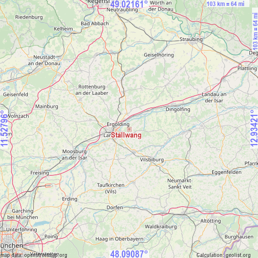
Stallwang GPS coordinates[2]
48° 33' 30.168" North, 12° 13' 51.888" East
| Map corner | latitude | longitude |
|---|---|---|
| Upper-left | 49.02161°, | 11.52796° |
| Center: | 48.55838°, | 12.23108° |
| Lower-right: | 48.09087°, | 12.93421° |
| Map W x H: | 103.5×103.5 km | = 64.3×64.3mi |
| max Lat: | 55.01917° ⇑88.4% North |
| Stallwang: | 48.55838° |
| min Lat: | ⇓11.6% South 47.40724° |
| min Long | Stallwang | max Long |
| 5.92978° | 12.23108° | 14.98853° |
| W 85.1%⇐ | ⇒14.9% E |
Elevation
Elevation of Stallwang is 427 m = 1401 ft, and this is 177.9 m = 584 ft above average elevation for this country.
| Max E: |
1256 m = 4121 ft | 21% |
| Stallwang | 427 m 1401 ft | |
| Avg. | 249.1 m = 817 ft | |
Min E: |
-5 m = -16 ft | 79% |
See also: Germany elevation on elevation.city.
Geographical zone
Stallwang is located in North temperate zone (between Tropic of Cancer and the Arctic Circle). Distance of this North polar circle is 2002 km =1244 mi to North.| Distance of | km | miles | from Stallwang |
|---|---|---|---|
| North Pole | 4607.9 | 2863.2 | to North |
| Arctic Circle | 2002 | 1244 | to North |
| Tropic Cancer | 2793.3 | 1735.7 | to South |
| Equator | 5399.2 | 3354.9 | to South |


Nearby cities:
15 places around Stallwang: (largest is in red/bold)
• Adlkofen
2.8 km =1.7 mi,  109°
109°
• Altfraunhofen
13 km =8.1 mi,  201°
201°
• Buch
11.6 km =7.2 mi,  334°
334°
• Eching
13.7 km =8.5 mi,  241°
241°
• Eging
11 km =6.8 mi, 196°
• Ergolding
4.9 km =3 mi,  294°
294°
• Essenbach
6.2 km =3.9 mi,  351°
351°
• Geisenhausen
9.4 km =5.8 mi,  167°
167°
• Kumhausen
7.7 km =4.8 mi,  225°
225°
• Landshut
6 km =3.7 mi, 237°
• Niederaichbach
7.8 km =4.8 mi,  53°
53°
• Niederviehbach
12.9 km =8 mi,  59°
59°
• Postau
12.7 km =7.9 mi,  36°
36°
• Tiefenbach
11.6 km =7.2 mi, 236°
• Wörth an der Isar
10.7 km =6.6 mi, 47°
Sources, notices
• [Note1] Compared only with cities in Germany existing in our database
• [Src1] Map data: © OpenStreetMap contributors (CC-BY-SA)
• [Src2] Other city data from geonames.org with taken over terms of usage.
• [Src3] Geographical zone / Annual Mean Temperature by Robert A. Rohde @ Wikipedia
