Landshut geodata
Landshut (Bavaria) is a seat of a second-order administrative division; located in Germany in Europe/Berlin (GMT+2) time zone. With population of 60,488 people, there are 171 cities with bigger population in this country. Compared to other cities in Germany, 88.8% of cities are located further ↑North; 84% of cities are located further ←West and 87.3% of cities have lower elevation than Landshut. Note1
Administrative division(s):
- Level 1: Bavaria
- Level 2: Lower Bavaria
- Level 3: Kreisfreie Stadt Landshut
- Level 4: Landshut


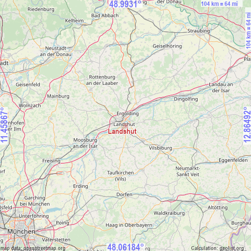
Landshut GPS coordinates[2]
48° 31' 46.596" North, 12° 9' 42.444" East
| Map corner | latitude | longitude |
|---|---|---|
| Upper-left | 48.9931°, | 11.45867° |
| Center: | 48.52961°, | 12.16179° |
| Lower-right: | 48.06184°, | 12.86492° |
| Map W x H: | 103.5×103.5 km | = 64.3×64.3mi |
| max Lat: | 55.01917° ⇑88.8% North |
| Landshut: | 48.52961° |
| min Lat: | ⇓11.2% South 47.40724° |
| min Long | Landshut | max Long |
| 5.92978° | 12.16179° | 14.98853° |
| W 84%⇐ | ⇒16% E |
Elevation
Elevation of Landshut is 488 m = 1601 ft, and this is 238.9 m = 784 ft above average elevation for this country.
| Max E: |
1256 m = 4121 ft | 12.7% |
| Landshut | 488 m 1601 ft | |
| Avg. | 249.1 m = 817 ft | |
Min E: |
-5 m = -16 ft | 87.3% |
See also: Landshut elevation on elevation.city.
Geographical zone
Landshut is located in North temperate zone (between Tropic of Cancer and the Arctic Circle). Distance of this North polar circle is 2005.2 km =1246 mi to North.| Distance of | km | miles | from Landshut |
|---|---|---|---|
| North Pole | 4611.1 | 2865.2 | to North |
| Arctic Circle | 2005.2 | 1246 | to North |
| Tropic Cancer | 2790.1 | 1733.7 | to South |
| Equator | 5396 | 3352.9 | to South |


Nearby cities:
15 places around Landshut: (largest is in red/bold)
• Adlkofen
8 km =5 mi,  73°
73°
• Altfraunhofen
8.9 km =5.5 mi,  177°
177°
• Baierbach
12.9 km =8 mi,  167°
167°
• Bruckberg
12.3 km =7.6 mi,  266°
266°
• Eching
7.7 km =4.8 mi,  244°
244°
• Eging
7.7 km =4.8 mi,  164°
164°
• Ergolding
5.3 km =3.3 mi,  7°
7°
• Essenbach
10.2 km =6.3 mi,  24°
24°
• Furth
12.4 km =7.7 mi,  303°
303°
• Geisenhausen
9.3 km =5.8 mi,  129°
129°
• Kumhausen
2.3 km =1.4 mi,  190°
190°
• Stallwang
6 km =3.7 mi,  57°
57°
• Tiefenbach
5.6 km =3.5 mi,  234°
234°
• Vilsheim
9.9 km =6.2 mi,  204°
204°
• Weihmichl
11.4 km =7.1 mi,  313°
313°
Sources, notices
• [Note1] Compared only with cities in Germany existing in our database
• [Src1] Map data: © OpenStreetMap contributors (CC-BY-SA)
• [Src2] Other city data from geonames.org with taken over terms of usage.
• [Src3] Geographical zone / Annual Mean Temperature by Robert A. Rohde @ Wikipedia
