Ergolding geodata
Ergolding (Bavaria) is a populated place; located in Germany in Europe/Berlin (GMT+2) time zone. With population of 11,438 people, there are 1442 cities with bigger population in this country. Compared to other cities in Germany, 88.1% of cities are located further ↑North; 84.2% of cities are located further ←West and 74.6% of cities have lower elevation than Ergolding. Note1
Administrative division(s):
- Level 1: Bavaria
- Level 2: Lower Bavaria
- Level 3: Landkreis Landshut
- Level 4: Ergolding, Markt


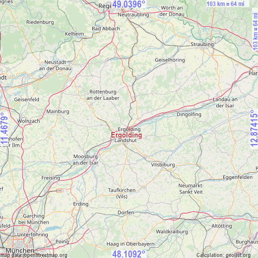
Ergolding GPS coordinates[2]
48° 34' 35.544" North, 12° 10' 15.672" East
| Map corner | latitude | longitude |
|---|---|---|
| Upper-left | 49.0396°, | 11.4679° |
| Center: | 48.57654°, | 12.17102° |
| Lower-right: | 48.1092°, | 12.87415° |
| Map W x H: | 103.5×103.4 km | = 64.3×64.2mi |
| max Lat: | 55.01917° ⇑88.1% North |
| Ergolding: | 48.57654° |
| min Lat: | ⇓11.9% South 47.40724° |
| min Long | Ergolding | max Long |
| 5.92978° | 12.17102° | 14.98853° |
| W 84.2%⇐ | ⇒15.8% E |
Elevation
Elevation of Ergolding is 394 m = 1293 ft, and this is 144.9 m = 475 ft above average elevation for this country.
| Max E: |
1256 m = 4121 ft | 25.4% |
| Ergolding | 394 m 1293 ft | |
| Avg. | 249.1 m = 817 ft | |
Min E: |
-5 m = -16 ft | 74.6% |
See also: Germany elevation on elevation.city.
Geographical zone
Ergolding is located in North temperate zone (between Tropic of Cancer and the Arctic Circle). Distance of this North polar circle is 2000 km =1242.7 mi to North.| Distance of | km | miles | from Ergolding |
|---|---|---|---|
| North Pole | 4605.9 | 2862 | to North |
| Arctic Circle | 2000 | 1242.7 | to North |
| Tropic Cancer | 2795.3 | 1736.9 | to South |
| Equator | 5401.2 | 3356.1 | to South |


Nearby cities:
15 places around Ergolding: (largest is in red/bold)
• Adlkofen
7.6 km =4.7 mi,  112°
112°
• Buch
8.4 km =5.2 mi,  356°
356°
• Eching
11.5 km =7.1 mi,  222°
222°
• Eging
12.7 km =7.9 mi,  173°
173°
• Ergoldsbach
13.1 km =8.1 mi,  10°
10°
• Essenbach
5.4 km =3.4 mi,  40°
40°
• Furth
11.2 km =7 mi,  278°
278°
• Geisenhausen
12.9 km =8 mi,  150°
150°
• Hohenthann
11 km =6.8 mi,  328°
328°
• Kumhausen
7.5 km =4.7 mi,  188°
188°
• Landshut
5.3 km =3.3 mi, 187°
• Niederaichbach
11 km =6.8 mi,  76°
76°
• Stallwang
4.9 km =3 mi, 114°
• Tiefenbach
10 km =6.2 mi,  211°
211°
• Weihmichl
9.3 km =5.8 mi,  286°
286°
Sources, notices
• [Note1] Compared only with cities in Germany existing in our database
• [Src1] Map data: © OpenStreetMap contributors (CC-BY-SA)
• [Src2] Other city data from geonames.org with taken over terms of usage.
• [Src3] Geographical zone / Annual Mean Temperature by Robert A. Rohde @ Wikipedia
