Erpolzheim geodata
Erpolzheim (Rheinland-Pfalz) is a seat of a fourth-order administrative division; located in Germany in Europe/Berlin (GMT+2) time zone. With population of 1,208 people, there are 6542 cities with bigger population in this country. Compared to other cities in Germany, 75.9% of cities are located further ↑North; 73.8% of cities are located further →East and 66.9% of cities have higher elevation than Erpolzheim. Note1
Administrative division(s):
- Level 1: Rheinland-Pfalz
- Level 3: Landkreis Bad Dürkheim
- Level 4: Erpolzheim


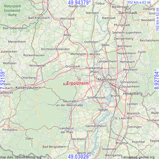
Erpolzheim GPS coordinates[2]
49° 29' 21.012" North, 8° 13' 28.992" East
| Map corner | latitude | longitude |
|---|---|---|
| Upper-left | 49.94379°, | 7.52159° |
| Center: | 49.48917°, | 8.22472° |
| Lower-right: | 49.03029°, | 8.92784° |
| Map W x H: | 101.6×101.6 km | = 63.1×63.1mi |
| max Lat: | 55.01917° ⇑75.9% North |
| Erpolzheim: | 49.48917° |
| min Lat: | ⇓24.1% South 47.40724° |
| min Long | Erpolzheim | max Long |
| 5.92978° | 8.22472° | 14.98853° |
| W 26.2%⇐ | ⇒73.8% E |
Elevation
Elevation of Erpolzheim is 109 m = 358 ft, and this is 140.1 m = 460 ft below average elevation for this country.
| Max E: |
1256 m = 4121 ft | 66.9% |
| Avg. | 249.1 m = 817 ft | |
| Erpolzheim | 109 m = 358 ft | |
Min E: |
-5 m = -16 ft | 33.1% |
See also: Germany elevation on elevation.city.
Geographical zone
Erpolzheim is located in North temperate zone (between Tropic of Cancer and the Arctic Circle). Distance of this North polar circle is 1898.5 km =1179.7 mi to North.| Distance of | km | miles | from Erpolzheim |
|---|---|---|---|
| North Pole | 4504.4 | 2798.9 | to North |
| Arctic Circle | 1898.5 | 1179.7 | to North |
| Tropic Cancer | 2896.8 | 1800 | to South |
| Equator | 5502.7 | 3419.2 | to South |


Nearby cities:
15 places around Erpolzheim: (largest is in red/bold)
• Bad Dürkheim
4.9 km =3 mi,  231°
231°
• Birkenheide
2.8 km =1.7 mi,  107°
107°
• Bissersheim
5.4 km =3.4 mi,  344°
344°
• Dackenheim
4.5 km =2.8 mi,  322°
322°
• Ellerstadt
4 km =2.5 mi,  140°
140°
• Freinsheim
2.1 km =1.3 mi,  334°
334°
• Friedelsheim
4.7 km =2.9 mi,  181°
181°
• Fußgönheim
5.8 km =3.6 mi,  122°
122°
• Großkarlbach
5.5 km =3.4 mi,  0°
0°
• Gönnheim
4.7 km =2.9 mi,  167°
167°
• Herxheim am Berg
4 km =2.5 mi,  304°
304°
• Kallstadt
3.5 km =2.2 mi,  273°
273°
• Lambsheim
5.3 km =3.3 mi,  59°
59°
• Maxdorf
4.8 km =3 mi,  91°
91°
• Weisenheim am Sand
3.6 km =2.2 mi,  27°
27°
Sources, notices
• [Note1] Compared only with cities in Germany existing in our database
• [Src1] Map data: © OpenStreetMap contributors (CC-BY-SA)
• [Src2] Other city data from geonames.org with taken over terms of usage.
• [Src3] Geographical zone / Annual Mean Temperature by Robert A. Rohde @ Wikipedia
