Sexau geodata
Sexau (Baden-Württemberg) is a seat of a fourth-order administrative division; located in Germany in Europe/Berlin (GMT+2) time zone. With population of 3,186 people, there are 3838 cities with bigger population in this country. Compared to other cities in Germany, 94% of cities are located further ↑North; 78.8% of cities are located further →East and 51.1% of cities have lower elevation than Sexau. Note1
Administrative division(s):
- Level 1: Baden-Württemberg
- Level 2: Freiburg Region
- Level 3: Landkreis Emmendingen
- Level 4: Sexau


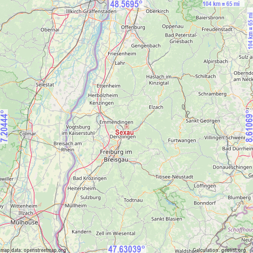
Sexau GPS coordinates[2]
48° 6' 7.524" North, 7° 54' 27.252" East
| Map corner | latitude | longitude |
|---|---|---|
| Upper-left | 48.5695°, | 7.20444° |
| Center: | 48.10209°, | 7.90757° |
| Lower-right: | 47.63039°, | 8.61069° |
| Map W x H: | 104.4×104.4 km | = 64.9×64.9mi |
| max Lat: | 55.01917° ⇑94% North |
| Sexau: | 48.10209° |
| min Lat: | ⇓6% South 47.40724° |
| min Long | Sexau | max Long |
| 5.92978° | 7.90757° | 14.98853° |
| W 21.2%⇐ | ⇒78.8% E |
Elevation
Elevation of Sexau is 234 m = 768 ft, and this is 15.1 m = 50 ft below average elevation for this country.
| Max E: |
1256 m = 4121 ft | 48.9% |
| Avg. | 249.1 m = 817 ft | |
| Sexau | 234 m = 768 ft | |
Min E: |
-5 m = -16 ft | 51.1% |
See also: Germany elevation on elevation.city.
Geographical zone
Sexau is located in North temperate zone (between Tropic of Cancer and the Arctic Circle). Distance of this North polar circle is 2052.7 km =1275.5 mi to North.| Distance of | km | miles | from Sexau |
|---|---|---|---|
| North Pole | 4658.6 | 2894.7 | to North |
| Arctic Circle | 2052.7 | 1275.5 | to North |
| Tropic Cancer | 2742.5 | 1704.1 | to South |
| Equator | 5348.5 | 3323.4 | to South |


Nearby cities:
15 places around Sexau: (largest is in red/bold)
• Bahlingen
12.6 km =7.8 mi,  279°
279°
• Buchheim
11.1 km =6.9 mi,  244°
244°
• Denzlingen
4.3 km =2.7 mi,  204°
204°
• Eichstetten
12.3 km =7.6 mi,  265°
265°
• Emmendingen
4.5 km =2.8 mi,  297°
297°
• Freiburg
12.5 km =7.8 mi, 199°
• Glottertal
7.1 km =4.4 mi,  143°
143°
• Gundelfingen
7.3 km =4.5 mi,  205°
205°
• Gutach im Breisgau
5.9 km =3.7 mi,  73°
73°
• Heuweiler
5.8 km =3.6 mi,  185°
185°
• Malterdingen
10.9 km =6.8 mi, 304°
• Teningen
7.7 km =4.8 mi,  293°
293°
• Umkirch
13 km =8.1 mi,  233°
233°
• Vörstetten
5.8 km =3.6 mi, 227°
• Waldkirch
4.2 km =2.6 mi,  99°
99°
Sources, notices
• [Note1] Compared only with cities in Germany existing in our database
• [Src1] Map data: © OpenStreetMap contributors (CC-BY-SA)
• [Src2] Other city data from geonames.org with taken over terms of usage.
• [Src3] Geographical zone / Annual Mean Temperature by Robert A. Rohde @ Wikipedia
