Schuttertal geodata
Schuttertal (Baden-Württemberg) is a seat of a fourth-order administrative division; located in Germany in Europe/Berlin (GMT+2) time zone. With population of 3,343 people, there are 3728 cities with bigger population in this country. Compared to other cities in Germany, 91.7% of cities are located further ↑North; 78.1% of cities are located further →East and 59.1% of cities have lower elevation than Schuttertal. Note1
Administrative division(s):
- Level 1: Baden-Württemberg
- Level 2: Freiburg Region
- Level 3: Ortenaukreis
- Level 4: Schuttertal


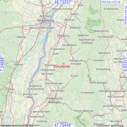
Schuttertal GPS coordinates[2]
48° 16' 0.012" North, 7° 57' 0" East
| Map corner | latitude | longitude |
|---|---|---|
| Upper-left | 48.73257°, | 7.24688° |
| Center: | 48.26667°, | 7.95° |
| Lower-right: | 47.79648°, | 8.65313° |
| Map W x H: | 104.1×104.1 km | = 64.7×64.7mi |
| max Lat: | 55.01917° ⇑91.7% North |
| Schuttertal: | 48.26667° |
| min Lat: | ⇓8.3% South 47.40724° |
| min Long | Schuttertal | max Long |
| 5.92978° | 7.95° | 14.98853° |
| W 21.9%⇐ | ⇒78.1% E |
Elevation
Elevation of Schuttertal is 284 m = 932 ft, and this is 34.9 m = 115 ft above average elevation for this country.
| Max E: |
1256 m = 4121 ft | 40.9% |
| Schuttertal | 284 m 932 ft | |
| Avg. | 249.1 m = 817 ft | |
Min E: |
-5 m = -16 ft | 59.1% |
See also: Germany elevation on elevation.city.
Geographical zone
Schuttertal is located in North temperate zone (between Tropic of Cancer and the Arctic Circle). Distance of this North polar circle is 2034.4 km =1264.1 mi to North.| Distance of | km | miles | from Schuttertal |
|---|---|---|---|
| North Pole | 4640.3 | 2883.3 | to North |
| Arctic Circle | 2034.4 | 1264.1 | to North |
| Tropic Cancer | 2760.8 | 1715.5 | to South |
| Equator | 5366.8 | 3334.8 | to South |


Nearby cities:
15 places around Schuttertal: (largest is in red/bold)
• Biberach
9.6 km =6 mi,  39°
39°
• Elzach
13.7 km =8.5 mi,  139°
139°
• Ettenheim
10.2 km =6.3 mi,  263°
263°
• Fischerbach
12 km =7.5 mi,  79°
79°
• Friesenheim
12.2 km =7.6 mi,  336°
336°
• Hofstetten
8.6 km =5.3 mi,  96°
96°
• Hohberg
7.3 km =4.5 mi,  329°
329°
• Kappel-Grafenhausen
13.7 km =8.5 mi,  277°
277°
• Kippenheim
9.8 km =6.1 mi,  289°
289°
• Lahr
10.2 km =6.3 mi,  323°
323°
• Mahlberg
10.3 km =6.4 mi, 282°
• Mühlenbach
12.5 km =7.8 mi, 98°
• Ringsheim
12.9 km =8 mi, 260°
• Seelbach
4.9 km =3 mi,  351°
351°
• Steinach
8.3 km =5.2 mi,  63°
63°
Sources, notices
• [Note1] Compared only with cities in Germany existing in our database
• [Src1] Map data: © OpenStreetMap contributors (CC-BY-SA)
• [Src2] Other city data from geonames.org with taken over terms of usage.
• [Src3] Geographical zone / Annual Mean Temperature by Robert A. Rohde @ Wikipedia
