Eichenried geodata
Eichenried (Bavaria) is a populated place; located in Germany in Europe/Berlin (GMT+2) time zone. With population of 2,035 people, there are 5014 cities with bigger population in this country. Compared to other cities in Germany, 91.5% of cities are located further ↑North; 78.5% of cities are located further ←West and 85.5% of cities have lower elevation than Eichenried. Note1
Administrative division(s):
- Level 1: Bavaria
- Level 2: Upper Bavaria
- Level 3: Landkreis Erding
- Level 4: Moosinning


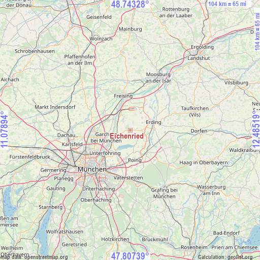
Eichenried GPS coordinates[2]
48° 16' 38.928" North, 11° 46' 55.416" East
| Map corner | latitude | longitude |
|---|---|---|
| Upper-left | 48.74328°, | 11.07894° |
| Center: | 48.27748°, | 11.78206° |
| Lower-right: | 47.80739°, | 12.48519° |
| Map W x H: | 104.1×104.1 km | = 64.7×64.7mi |
| max Lat: | 55.01917° ⇑91.5% North |
| Eichenried: | 48.27748° |
| min Lat: | ⇓8.5% South 47.40724° |
| min Long | Eichenried | max Long |
| 5.92978° | 11.78206° | 14.98853° |
| W 78.5%⇐ | ⇒21.5% E |
Elevation
Elevation of Eichenried is 473 m = 1552 ft, and this is 223.9 m = 735 ft above average elevation for this country.
| Max E: |
1256 m = 4121 ft | 14.5% |
| Eichenried | 473 m 1552 ft | |
| Avg. | 249.1 m = 817 ft | |
Min E: |
-5 m = -16 ft | 85.5% |
See also: Germany elevation on elevation.city.
Geographical zone
Eichenried is located in North temperate zone (between Tropic of Cancer and the Arctic Circle). Distance of this North polar circle is 2033.2 km =1263.4 mi to North.| Distance of | km | miles | from Eichenried |
|---|---|---|---|
| North Pole | 4639.1 | 2882.6 | to North |
| Arctic Circle | 2033.2 | 1263.4 | to North |
| Tropic Cancer | 2762 | 1716.2 | to South |
| Equator | 5368 | 3335.5 | to South |


Nearby cities:
15 places around Eichenried: (largest is in red/bold)
• Eitting
12.2 km =7.6 mi,  41°
41°
• Erding
9.8 km =6.1 mi,  71°
71°
• Finsing
7.5 km =4.7 mi,  155°
155°
• Garching bei München
10.2 km =6.3 mi,  251°
251°
• Hallbergmoos
6 km =3.7 mi,  337°
337°
• Ismaning
8.8 km =5.5 mi,  236°
236°
• Kirchheim bei München
11.4 km =7.1 mi,  189°
189°
• Markt Schwaben
11.7 km =7.3 mi,  146°
146°
• Moosinning
4.6 km =2.9 mi,  90°
90°
• Neufahrn bei Freising
9.8 km =6.1 mi,  295°
295°
• Oberding
6.7 km =4.2 mi,  49°
49°
• Ottenhofen
10.1 km =6.3 mi,  132°
132°
• Pliening
9.2 km =5.7 mi,  171°
171°
• Stammham
6.8 km =4.2 mi, 72°
• Wörth
9.6 km =6 mi,  111°
111°
Sources, notices
• [Note1] Compared only with cities in Germany existing in our database
• [Src1] Map data: © OpenStreetMap contributors (CC-BY-SA)
• [Src2] Other city data from geonames.org with taken over terms of usage.
• [Src3] Geographical zone / Annual Mean Temperature by Robert A. Rohde @ Wikipedia
