Erding geodata
Erding (Bavaria) is a seat of a third-order administrative division; located in Germany in Europe/Berlin (GMT+2) time zone. With population of 33,519 people, there are 405 cities with bigger population in this country. Compared to other cities in Germany, 91.2% of cities are located further ↑North; 80.4% of cities are located further ←West and 84.7% of cities have lower elevation than Erding. Note1
Administrative division(s):
- Level 1: Bavaria
- Level 2: Upper Bavaria
- Level 3: Landkreis Erding
- Level 4: Erding


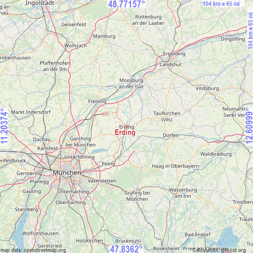
Erding GPS coordinates[2]
48° 18' 21.708" North, 11° 54' 24.696" East
| Map corner | latitude | longitude |
|---|---|---|
| Upper-left | 48.77157°, | 11.20374° |
| Center: | 48.30603°, | 11.90686° |
| Lower-right: | 47.8362°, | 12.60999° |
| Map W x H: | 104×104 km | = 64.6×64.6mi |
| max Lat: | 55.01917° ⇑91.2% North |
| Erding: | 48.30603° |
| min Lat: | ⇓8.8% South 47.40724° |
| min Long | Erding | max Long |
| 5.92978° | 11.90686° | 14.98853° |
| W 80.4%⇐ | ⇒19.6% E |
Elevation
Elevation of Erding is 466 m = 1529 ft, and this is 216.9 m = 712 ft above average elevation for this country.
| Max E: |
1256 m = 4121 ft | 15.3% |
| Erding | 466 m 1529 ft | |
| Avg. | 249.1 m = 817 ft | |
Min E: |
-5 m = -16 ft | 84.7% |
See also: Germany elevation on elevation.city.
Geographical zone
Erding is located in North temperate zone (between Tropic of Cancer and the Arctic Circle). Distance of this North polar circle is 2030 km =1261.4 mi to North.| Distance of | km | miles | from Erding |
|---|---|---|---|
| North Pole | 4635.9 | 2880.6 | to North |
| Arctic Circle | 2030 | 1261.4 | to North |
| Tropic Cancer | 2765.2 | 1718.2 | to South |
| Equator | 5371.1 | 3337.4 | to South |


Nearby cities:
15 places around Erding: (largest is in red/bold)
• Berglern
8.8 km =5.5 mi,  11°
11°
• Bockhorn
6 km =3.7 mi,  80°
80°
• Buch am Buchrain
12 km =7.5 mi,  147°
147°
• Eichenried
9.8 km =6.1 mi,  251°
251°
• Eitting
6.1 km =3.8 mi,  348°
348°
• Finsing
11.7 km =7.3 mi,  211°
211°
• Fraunberg
9.6 km =6 mi,  45°
45°
• Hallbergmoos
11.7 km =7.3 mi,  281°
281°
• Lengdorf
11.9 km =7.4 mi,  117°
117°
• Moosinning
5.6 km =3.5 mi,  235°
235°
• Oberding
4.4 km =2.7 mi,  285°
285°
• Ottenhofen
10.1 km =6.3 mi,  189°
189°
• Stammham
3 km =1.9 mi, 248°
• Walpertskirchen
7.3 km =4.5 mi,  136°
136°
• Wörth
6.8 km =4.2 mi,  182°
182°
Sources, notices
• [Note1] Compared only with cities in Germany existing in our database
• [Src1] Map data: © OpenStreetMap contributors (CC-BY-SA)
• [Src2] Other city data from geonames.org with taken over terms of usage.
• [Src3] Geographical zone / Annual Mean Temperature by Robert A. Rohde @ Wikipedia
