Pliening geodata
Pliening (Bavaria) is a seat of a fourth-order administrative division; located in Germany in Europe/Berlin (GMT+2) time zone. With population of 4,812 people, there are 2896 cities with bigger population in this country. Compared to other cities in Germany, 92.7% of cities are located further ↑North; 78.9% of cities are located further ←West and 89% of cities have lower elevation than Pliening. Note1
Administrative division(s):
- Level 1: Bavaria
- Level 2: Upper Bavaria
- Level 3: Landkreis Ebersberg
- Level 4: Pliening


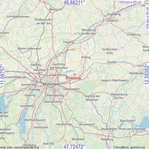
Pliening GPS coordinates[2]
48° 11' 44.016" North, 11° 48' 2.484" East
| Map corner | latitude | longitude |
|---|---|---|
| Upper-left | 48.66211°, | 11.09757° |
| Center: | 48.19556°, | 11.80069° |
| Lower-right: | 47.72472°, | 12.50382° |
| Map W x H: | 104.2×104.2 km | = 64.7×64.7mi |
| max Lat: | 55.01917° ⇑92.7% North |
| Pliening: | 48.19556° |
| min Lat: | ⇓7.3% South 47.40724° |
| min Long | Pliening | max Long |
| 5.92978° | 11.80069° | 14.98853° |
| W 78.9%⇐ | ⇒21.1% E |
Elevation
Elevation of Pliening is 504 m = 1654 ft, and this is 254.9 m = 836 ft above average elevation for this country.
| Max E: |
1256 m = 4121 ft | 11% |
| Pliening | 504 m 1654 ft | |
| Avg. | 249.1 m = 817 ft | |
Min E: |
-5 m = -16 ft | 89% |
See also: Germany elevation on elevation.city.
Geographical zone
Pliening is located in North temperate zone (between Tropic of Cancer and the Arctic Circle). Distance of this North polar circle is 2042.3 km =1269 mi to North.| Distance of | km | miles | from Pliening |
|---|---|---|---|
| North Pole | 4648.2 | 2888.3 | to North |
| Arctic Circle | 2042.3 | 1269 | to North |
| Tropic Cancer | 2752.9 | 1710.6 | to South |
| Equator | 5358.8 | 3329.8 | to South |


Nearby cities:
15 places around Pliening: (largest is in red/bold)
• Anzing
6.2 km =3.9 mi,  141°
141°
• Aschheim
6.8 km =4.2 mi,  246°
246°
• Eichenried
9.2 km =5.7 mi,  351°
351°
• Feldkirchen
7.4 km =4.6 mi,  224°
224°
• Finsing
2.9 km =1.8 mi,  37°
37°
• Forstinning
8.8 km =5.5 mi,  109°
109°
• Ismaning
9.7 km =6 mi,  295°
295°
• Kirchheim bei München
4 km =2.5 mi,  237°
237°
• Markt Schwaben
5.1 km =3.2 mi,  97°
97°
• Moosinning
9.6 km =6 mi,  19°
19°
• Ottenhofen
6.6 km =4.1 mi,  69°
69°
• Pastetten
10.6 km =6.6 mi,  87°
87°
• Poing
3.1 km =1.9 mi,  154°
154°
• Vaterstetten
10.3 km =6.4 mi,  193°
193°
• Wörth
9.3 km =5.8 mi,  53°
53°
Sources, notices
• [Note1] Compared only with cities in Germany existing in our database
• [Src1] Map data: © OpenStreetMap contributors (CC-BY-SA)
• [Src2] Other city data from geonames.org with taken over terms of usage.
• [Src3] Geographical zone / Annual Mean Temperature by Robert A. Rohde @ Wikipedia
