Egglham geodata
Egglham (Bavaria) is a seat of a fourth-order administrative division; located in Germany in Europe/Berlin (GMT+2) time zone. With population of 2,439 people, there are 4515 cities with bigger population in this country. Compared to other cities in Germany, 88.8% of cities are located further ↑North; 92.6% of cities are located further ←West and 69% of cities have lower elevation than Egglham. Note1
Administrative division(s):
- Level 1: Bavaria
- Level 2: Lower Bavaria
- Level 3: Landkreis Rottal-Inn
- Level 4: Egglham


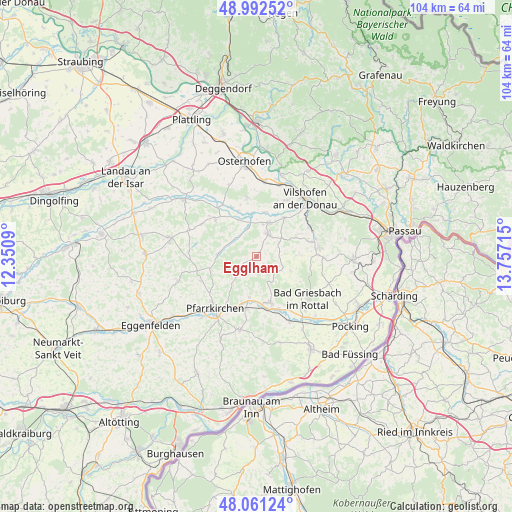
Egglham GPS coordinates[2]
48° 31' 44.472" North, 13° 3' 14.472" East
| Map corner | latitude | longitude |
|---|---|---|
| Upper-left | 48.99252°, | 12.3509° |
| Center: | 48.52902°, | 13.05402° |
| Lower-right: | 48.06124°, | 13.75715° |
| Map W x H: | 103.5×103.5 km | = 64.3×64.3mi |
| max Lat: | 55.01917° ⇑88.8% North |
| Egglham: | 48.52902° |
| min Lat: | ⇓11.2% South 47.40724° |
| min Long | Egglham | max Long |
| 5.92978° | 13.05402° | 14.98853° |
| W 92.6%⇐ | ⇒7.4% E |
Elevation
Elevation of Egglham is 351 m = 1152 ft, and this is 101.9 m = 334 ft above average elevation for this country.
| Max E: |
1256 m = 4121 ft | 31% |
| Egglham | 351 m 1152 ft | |
| Avg. | 249.1 m = 817 ft | |
Min E: |
-5 m = -16 ft | 69% |
See also: Germany elevation on elevation.city.
Geographical zone
Egglham is located in North temperate zone (between Tropic of Cancer and the Arctic Circle). Distance of this North polar circle is 2005.3 km =1246 mi to North.| Distance of | km | miles | from Egglham |
|---|---|---|---|
| North Pole | 4611.1 | 2865.2 | to North |
| Arctic Circle | 2005.3 | 1246 | to North |
| Tropic Cancer | 2790 | 1733.6 | to South |
| Equator | 5395.9 | 3352.9 | to South |


Nearby cities:
15 places around Egglham: (largest is in red/bold)
• Aidenbach
5.3 km =3.3 mi,  29°
29°
• Aldersbach
7.2 km =4.5 mi,  21°
21°
• Bad Birnbach
9.7 km =6 mi,  163°
163°
• Bad Griesbach
13.4 km =8.3 mi,  129°
129°
• Bayerbach
14.8 km =9.2 mi,  153°
153°
• Beutelsbach
5.2 km =3.2 mi,  63°
63°
• Dietersburg
10.3 km =6.4 mi,  246°
246°
• Haarbach
7.8 km =4.8 mi,  114°
114°
• Haibach
5 km =3.1 mi,  279°
279°
• Johanniskirchen
7.7 km =4.8 mi,  273°
273°
• Ortenburg
12.5 km =7.8 mi,  81°
81°
• Pfarrkirchen
13.8 km =8.6 mi,  218°
218°
• Reut
8.6 km =5.3 mi,  36°
36°
• Rossbach
9.8 km =6.1 mi,  308°
308°
• Roßbach
11.9 km =7.4 mi, 311°
Sources, notices
• [Note1] Compared only with cities in Germany existing in our database
• [Src1] Map data: © OpenStreetMap contributors (CC-BY-SA)
• [Src2] Other city data from geonames.org with taken over terms of usage.
• [Src3] Geographical zone / Annual Mean Temperature by Robert A. Rohde @ Wikipedia
