Pfarrkirchen geodata
Pfarrkirchen (Bavaria) is a seat of a third-order administrative division; located in Germany in Europe/Berlin (GMT+2) time zone. With population of 11,894 people, there are 1379 cities with bigger population in this country. Compared to other cities in Germany, 89.9% of cities are located further ↑North; 91.8% of cities are located further ←West and 73.2% of cities have lower elevation than Pfarrkirchen. Note1
Administrative division(s):
- Level 1: Bavaria
- Level 2: Lower Bavaria
- Level 3: Landkreis Rottal-Inn
- Level 4: Pfarrkirchen


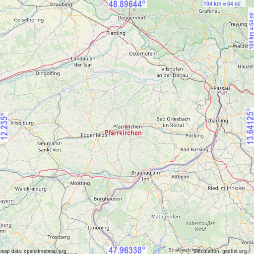
Pfarrkirchen GPS coordinates[2]
48° 25' 55.38" North, 12° 56' 17.232" East
| Map corner | latitude | longitude |
|---|---|---|
| Upper-left | 48.89644°, | 12.235° |
| Center: | 48.43205°, | 12.93812° |
| Lower-right: | 47.96338°, | 13.64125° |
| Map W x H: | 103.7×103.7 km | = 64.4×64.4mi |
| max Lat: | 55.01917° ⇑89.9% North |
| Pfarrkirchen: | 48.43205° |
| min Lat: | ⇓10.1% South 47.40724° |
| min Long | Pfarrkirchen | max Long |
| 5.92978° | 12.93812° | 14.98853° |
| W 91.8%⇐ | ⇒8.2% E |
Elevation
Elevation of Pfarrkirchen is 384 m = 1260 ft, and this is 134.9 m = 443 ft above average elevation for this country.
| Max E: |
1256 m = 4121 ft | 26.8% |
| Pfarrkirchen | 384 m 1260 ft | |
| Avg. | 249.1 m = 817 ft | |
Min E: |
-5 m = -16 ft | 73.2% |
See also: Germany elevation on elevation.city.
Geographical zone
Pfarrkirchen is located in North temperate zone (between Tropic of Cancer and the Arctic Circle). Distance of this North polar circle is 2016 km =1252.7 mi to North.| Distance of | km | miles | from Pfarrkirchen |
|---|---|---|---|
| North Pole | 4621.9 | 2871.9 | to North |
| Arctic Circle | 2016 | 1252.7 | to North |
| Tropic Cancer | 2779.2 | 1726.9 | to South |
| Equator | 5385.1 | 3346.1 | to South |


Nearby cities:
15 places around Pfarrkirchen: (largest is in red/bold)
• Bad Birnbach
11.4 km =7.1 mi,  82°
82°
• Chostlarn
15.1 km =9.4 mi,  116°
116°
• Dietersburg
6.8 km =4.2 mi,  351°
351°
• Eggenfelden
13.7 km =8.5 mi,  257°
257°
• Egglham
13.8 km =8.6 mi,  38°
38°
• Haibach
12.2 km =7.6 mi,  17°
17°
• Hebertsfelden
9 km =5.6 mi,  251°
251°
• Johanniskirchen
11.3 km =7 mi,  4°
4°
• Postmünster
3.3 km =2.1 mi,  238°
238°
• Reut
12.8 km =8 mi,  181°
181°
• Schönau
8.6 km =5.3 mi,  311°
311°
• Tann
13.5 km =8.4 mi,  194°
194°
• Triftern
6.5 km =4 mi,  129°
129°
• Wittibreut
12 km =7.5 mi,  162°
162°
• Wurmannsquick
14.2 km =8.8 mi,  232°
232°
Sources, notices
• [Note1] Compared only with cities in Germany existing in our database
• [Src1] Map data: © OpenStreetMap contributors (CC-BY-SA)
• [Src2] Other city data from geonames.org with taken over terms of usage.
• [Src3] Geographical zone / Annual Mean Temperature by Robert A. Rohde @ Wikipedia
