Rossbach geodata
Rossbach (Bavaria) is a populated locality; located in Germany in Europe/Berlin (GMT+2) time zone. With population of 2,944 people, there are 4050 cities with bigger population in this country. Compared to other cities in Germany, 88.1% of cities are located further ↑North; 91.9% of cities are located further ←West and 75.3% of cities have lower elevation than Rossbach. Note1
Administrative division(s):
- Level 1: Bavaria
- Level 2: Lower Bavaria
- Level 3: Landkreis Rottal-Inn
- Level 4: Roßbach


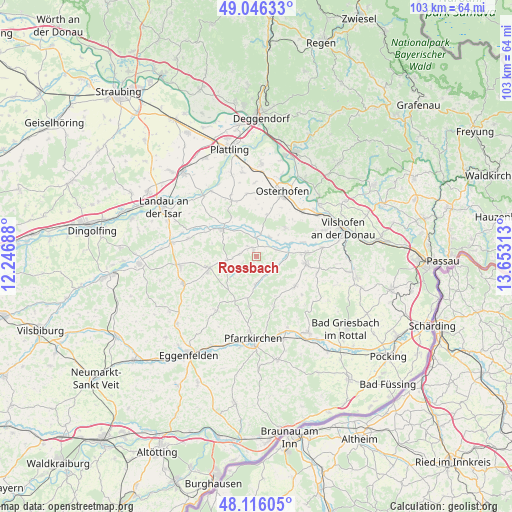
Rossbach GPS coordinates[2]
48° 34' 59.988" North, 12° 57' 0" East
| Map corner | latitude | longitude |
|---|---|---|
| Upper-left | 49.04633°, | 12.24688° |
| Center: | 48.58333°, | 12.95° |
| Lower-right: | 48.11605°, | 13.65313° |
| Map W x H: | 103.4×103.4 km | = 64.2×64.2mi |
| max Lat: | 55.01917° ⇑88.1% North |
| Rossbach: | 48.58333° |
| min Lat: | ⇓11.9% South 47.40724° |
| min Long | Rossbach | max Long |
| 5.92978° | 12.95° | 14.98853° |
| W 91.9%⇐ | ⇒8.1% E |
Elevation
Elevation of Rossbach is 400 m = 1312 ft, and this is 150.9 m = 495 ft above average elevation for this country.
| Max E: |
1256 m = 4121 ft | 24.7% |
| Rossbach | 400 m 1312 ft | |
| Avg. | 249.1 m = 817 ft | |
Min E: |
-5 m = -16 ft | 75.3% |
See also: Germany elevation on elevation.city.
Geographical zone
Rossbach is located in North temperate zone (between Tropic of Cancer and the Arctic Circle). Distance of this North polar circle is 1999.2 km =1242.2 mi to North.| Distance of | km | miles | from Rossbach |
|---|---|---|---|
| North Pole | 4605.1 | 2861.5 | to North |
| Arctic Circle | 1999.2 | 1242.2 | to North |
| Tropic Cancer | 2796 | 1737.4 | to South |
| Equator | 5402 | 3356.6 | to South |


Nearby cities:
15 places around Rossbach: (largest is in red/bold)
• Aidenbach
10.4 km =6.5 mi,  98°
98°
• Aldersbach
10.3 km =6.4 mi,  86°
86°
• Arnstorf
10.2 km =6.3 mi,  254°
254°
• Beutelsbach
12.8 km =8 mi,  106°
106°
• Buchhofen
12.8 km =8 mi,  351°
351°
• Dietersburg
10.3 km =6.4 mi,  190°
190°
• Egglham
9.8 km =6.1 mi,  128°
128°
• Eichendorf
8.8 km =5.5 mi,  308°
308°
• Haibach
5.9 km =3.7 mi,  152°
152°
• Johanniskirchen
5.6 km =3.5 mi,  180°
180°
• Künzing
13.5 km =8.4 mi,  46°
46°
• Reut
12.8 km =8 mi, 85°
• Roßbach
2.2 km =1.4 mi,  326°
326°
• Schönau
13.3 km =8.3 mi,  213°
213°
• Wallerfing
12.3 km =7.6 mi,  335°
335°
Sources, notices
• [Note1] Compared only with cities in Germany existing in our database
• [Src1] Map data: © OpenStreetMap contributors (CC-BY-SA)
• [Src2] Other city data from geonames.org with taken over terms of usage.
• [Src3] Geographical zone / Annual Mean Temperature by Robert A. Rohde @ Wikipedia
