Heusenstamm geodata
Heusenstamm (Hesse) is a populated place; located in Germany in Europe/Berlin (GMT+2) time zone. With population of 19,012 people, there are 822 cities with bigger population in this country. Compared to other cities in Germany, 62.3% of cities are located further ↑North; 67.9% of cities are located further →East and 63.3% of cities have higher elevation than Heusenstamm. Note1
Administrative division(s):
- Level 1: Hesse
- Level 2: Regierungsbezirk Darmstadt
- Level 3: Landkreis Offenbach
- Level 4: Heusenstamm


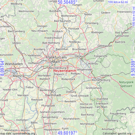
Heusenstamm GPS coordinates[2]
50° 3' 19.908" North, 8° 48' 2.736" East
| Map corner | latitude | longitude |
|---|---|---|
| Upper-left | 50.50485°, | 8.09764° |
| Center: | 50.05553°, | 8.80076° |
| Lower-right: | 49.60197°, | 9.50389° |
| Map W x H: | 100.4×100.4 km | = 62.4×62.4mi |
| max Lat: | 55.01917° ⇑62.3% North |
| Heusenstamm: | 50.05553° |
| min Lat: | ⇓37.7% South 47.40724° |
| min Long | Heusenstamm | max Long |
| 5.92978° | 8.80076° | 14.98853° |
| W 32.1%⇐ | ⇒67.9% E |
Elevation
Elevation of Heusenstamm is 130 m = 427 ft, and this is 119.1 m = 391 ft below average elevation for this country.
| Max E: |
1256 m = 4121 ft | 63.3% |
| Avg. | 249.1 m = 817 ft | |
| Heusenstamm | 130 m = 427 ft | |
Min E: |
-5 m = -16 ft | 36.7% |
See also: Germany elevation on elevation.city.
Geographical zone
Heusenstamm is located in North temperate zone (between Tropic of Cancer and the Arctic Circle). Distance of this North polar circle is 1835.5 km =1140.5 mi to North.| Distance of | km | miles | from Heusenstamm |
|---|---|---|---|
| North Pole | 4441.4 | 2759.8 | to North |
| Arctic Circle | 1835.5 | 1140.5 | to North |
| Tropic Cancer | 2959.7 | 1839.1 | to South |
| Equator | 5565.7 | 3458.4 | to South |


Nearby cities:
15 places around Heusenstamm: (largest is in red/bold)
• Dietzenbach
5.3 km =3.3 mi,  197°
197°
• Dreieich
8.5 km =5.3 mi,  242°
242°
• Eppertshausen
12.3 km =7.6 mi,  161°
161°
• Frankfurt am Main
10.7 km =6.6 mi,  308°
308°
• Gallus
13.2 km =8.2 mi,  292°
292°
• Hanau am Main
11.9 km =7.4 mi,  42°
42°
• Langen
12 km =7.5 mi,  232°
232°
• Maintal
10.8 km =6.7 mi,  12°
12°
• Mühlheim am Main
7.2 km =4.5 mi,  18°
18°
• Neu Isenburg
7.7 km =4.8 mi,  263°
263°
• Niederrad
12.7 km =7.9 mi,  283°
283°
• Obertshausen
4 km =2.5 mi,  63°
63°
• Offenbach
5.6 km =3.5 mi,  333°
333°
• Rodgau
6.9 km =4.3 mi,  118°
118°
• Seligenstadt
12.4 km =7.7 mi,  96°
96°
Sources, notices
• [Note1] Compared only with cities in Germany existing in our database
• [Src1] Map data: © OpenStreetMap contributors (CC-BY-SA)
• [Src2] Other city data from geonames.org with taken over terms of usage.
• [Src3] Geographical zone / Annual Mean Temperature by Robert A. Rohde @ Wikipedia
