Oldenburg geodata
Oldenburg (Lower Saxony) is a seat of a third-order administrative division; located in Germany in Europe/Berlin (GMT+2) time zone. With population of 159,218 people, there are 59 cities with bigger population in this country. Compared to other cities in Germany, 82.5% of cities are located further ↓South; 73.9% of cities are located further →East and 94.3% of cities have higher elevation than Oldenburg. Note1
Administrative division(s):
- Level 1: Lower Saxony
- Level 3: Kreisfreie Stadt Oldenburg
- Level 4: Oldenburg (Oldenburg)


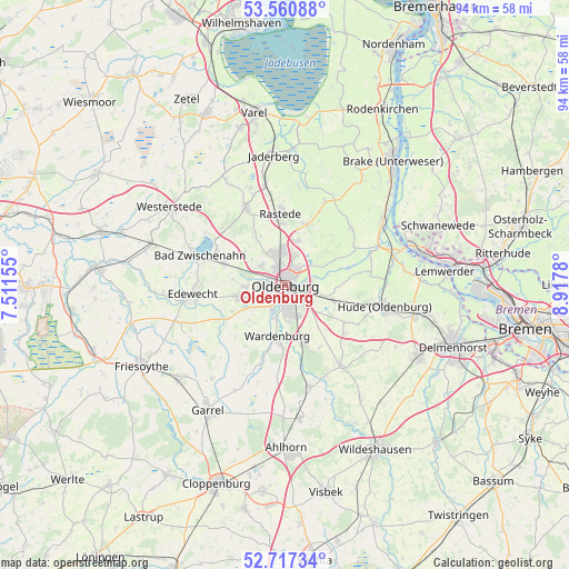
Oldenburg GPS coordinates[2]
53° 8' 28.248" North, 8° 12' 52.812" East
| Map corner | latitude | longitude |
|---|---|---|
| Upper-left | 53.56088°, | 7.51155° |
| Center: | 53.14118°, | 8.21467° |
| Lower-right: | 52.71734°, | 8.9178° |
| Map W x H: | 93.8×93.8 km | = 58.3×58.3mi |
| max Lat: | 55.01917° ⇑17.5% North |
| Oldenburg: | 53.14118° |
| min Lat: | ⇓82.5% South 47.40724° |
| min Long | Oldenburg | max Long |
| 5.92978° | 8.21467° | 14.98853° |
| W 26.1%⇐ | ⇒73.9% E |
Elevation
Elevation of Oldenburg is 10 m = 33 ft, and this is 239.1 m = 784 ft below average elevation for this country.
| Max E: |
1256 m = 4121 ft | 94.3% |
| Avg. | 249.1 m = 817 ft | |
| Oldenburg | 10 m = 33 ft | |
Min E: |
-5 m = -16 ft | 5.7% |
See also: Oldenburg elevation on elevation.city.
Geographical zone
Oldenburg is located in North temperate zone (between Tropic of Cancer and the Arctic Circle). Distance of this North polar circle is 1492.4 km =927.3 mi to North.| Distance of | km | miles | from Oldenburg |
|---|---|---|---|
| North Pole | 4098.3 | 2546.6 | to North |
| Arctic Circle | 1492.4 | 927.3 | to North |
| Tropic Cancer | 3302.8 | 2052.3 | to South |
| Equator | 5908.7 | 3671.5 | to South |


Nearby cities:
15 places around Oldenburg: (largest is in red/bold)
• Bad Zwischenahn
15.1 km =9.4 mi,  288°
288°
• Bösel
23.6 km =14.7 mi,  228°
228°
• Dötlingen
25.7 km =16 mi,  153°
153°
• Edewecht
15.5 km =9.6 mi,  264°
264°
• Elsfleth
19.4 km =12.1 mi,  56°
56°
• Ganderkesee
24.4 km =15.2 mi,  119°
119°
• Garrel
25 km =15.5 mi,  211°
211°
• Großenkneten
22.1 km =13.7 mi,  173°
173°
• Hatten
15.2 km =9.4 mi,  131°
131°
• Hude
17 km =10.6 mi,  102°
102°
• Neuenkirchen
23.1 km =14.4 mi, 64°
• Rastede
12.1 km =7.5 mi,  355°
355°
• Wardenburg
8.3 km =5.2 mi,  186°
186°
• Westerstede
23.1 km =14.4 mi,  303°
303°
• Wiefelstede
13.7 km =8.5 mi,  331°
331°
In other languages:
- In Spanish: Oldenburg, Oldenburgo
- In France: Oldenbourg
- In Russian: Ольденбург
- In Chinese: 奥尔登堡
Sources, notices
• [Note1] Compared only with cities in Germany existing in our database
• [Src1] Map data: © OpenStreetMap contributors (CC-BY-SA)
• [Src2] Other city data from geonames.org with taken over terms of usage.
• [Src3] Geographical zone / Annual Mean Temperature by Robert A. Rohde @ Wikipedia
