Westerstede geodata
Westerstede (Lower Saxony) is a seat of a third-order administrative division; located in Germany in Europe/Berlin (GMT+2) time zone. With population of 21,902 people, there are 688 cities with bigger population in this country. Compared to other cities in Germany, 83.3% of cities are located further ↓South; 78.5% of cities are located further →East and 95.2% of cities have higher elevation than Westerstede. Note1


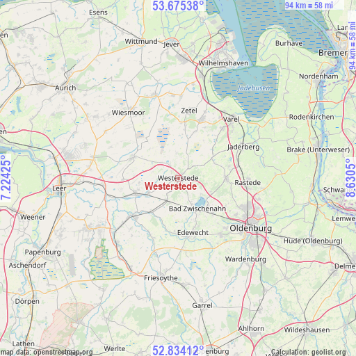
Westerstede GPS coordinates[2]
53° 15' 24.552" North, 7° 55' 38.532" East
| Map corner | latitude | longitude |
|---|---|---|
| Upper-left | 53.67538°, | 7.22425° |
| Center: | 53.25682°, | 7.92737° |
| Lower-right: | 52.83412°, | 8.6305° |
| Map W x H: | 93.5×93.5 km | = 58.1×58.1mi |
| max Lat: | 55.01917° ⇑16.7% North |
| Westerstede: | 53.25682° |
| min Lat: | ⇓83.3% South 47.40724° |
| min Long | Westerstede | max Long |
| 5.92978° | 7.92737° | 14.98853° |
| W 21.5%⇐ | ⇒78.5% E |
Elevation
Elevation of Westerstede is 8 m = 26 ft, and this is 241.1 m = 791 ft below average elevation for this country.
| Max E: |
1256 m = 4121 ft | 95.2% |
| Avg. | 249.1 m = 817 ft | |
| Westerstede | 8 m = 26 ft | |
Min E: |
-5 m = -16 ft | 4.8% |
See also: Germany elevation on elevation.city.
Geographical zone
Westerstede is located in North temperate zone (between Tropic of Cancer and the Arctic Circle). Distance of this North polar circle is 1479.6 km =919.4 mi to North.| Distance of | km | miles | from Westerstede |
|---|---|---|---|
| North Pole | 4085.5 | 2538.6 | to North |
| Arctic Circle | 1479.6 | 919.4 | to North |
| Tropic Cancer | 3315.7 | 2060.3 | to South |
| Equator | 5921.6 | 3679.5 | to South |


Nearby cities:
15 places around Westerstede: (largest is in red/bold)
• Apen
9.6 km =6 mi,  242°
242°
• Bad Zwischenahn
9.5 km =5.9 mi,  149°
149°
• Barßel
15.3 km =9.5 mi,  230°
230°
• Bockhorn
17 km =10.6 mi,  20°
20°
• Detern
17.7 km =11 mi,  252°
252°
• Edewecht
14.9 km =9.3 mi,  165°
165°
• Filsum
20 km =12.4 mi,  265°
265°
• Firrel
19.3 km =12 mi,  296°
296°
• Hesel
22.3 km =13.9 mi,  282°
282°
• Rastede
18.2 km =11.3 mi,  92°
92°
• Schwerinsdorf
18.7 km =11.6 mi,  288°
288°
• Varel
20.9 km =13 mi,  41°
41°
• Wiefelstede
12.6 km =7.8 mi, 93°
• Wiesmoor
22 km =13.7 mi,  324°
324°
• Zetel
18.2 km =11.3 mi,  11°
11°
Sources, notices
• [Note1] Compared only with cities in Germany existing in our database
• [Src1] Map data: © OpenStreetMap contributors (CC-BY-SA)
• [Src2] Other city data from geonames.org with taken over terms of usage.
• [Src3] Geographical zone / Annual Mean Temperature by Robert A. Rohde @ Wikipedia
