Bad Zwischenahn geodata
Bad Zwischenahn (Lower Saxony) is a seat of a fourth-order administrative division; located in Germany in Europe/Berlin (GMT+2) time zone. With population of 27,550 people, there are 517 cities with bigger population in this country. Compared to other cities in Germany, 82.7% of cities are located further ↓South; 77.2% of cities are located further →East and 94.8% of cities have higher elevation than Bad Zwischenahn. Note1
Administrative division(s):
- Level 1: Lower Saxony
- Level 3: Landkreis Ammerland
- Level 4: Bad Zwischenahn


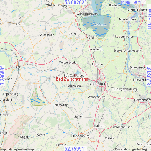
Bad Zwischenahn GPS coordinates[2]
53° 10' 59.988" North, 8° 0' 0" East
| Map corner | latitude | longitude |
|---|---|---|
| Upper-left | 53.60262°, | 7.29688° |
| Center: | 53.18333°, | 8° |
| Lower-right: | 52.75991°, | 8.70313° |
| Map W x H: | 93.7×93.7 km | = 58.2×58.2mi |
| max Lat: | 55.01917° ⇑17.3% North |
| Bad Zwischenahn: | 53.18333° |
| min Lat: | ⇓82.7% South 47.40724° |
| min Long | Bad Zwischenahn | max Long |
| 5.92978° | 8° | 14.98853° |
| W 22.8%⇐ | ⇒77.2% E |
Elevation
Elevation of Bad Zwischenahn is 9 m = 30 ft, and this is 240.1 m = 788 ft below average elevation for this country.
| Max E: |
1256 m = 4121 ft | 94.8% |
| Avg. | 249.1 m = 817 ft | |
| Bad Zwischenahn | 9 m = 30 ft | |
Min E: |
-5 m = -16 ft | 5.2% |
See also: Germany elevation on elevation.city.
Geographical zone
Bad Zwischenahn is located in North temperate zone (between Tropic of Cancer and the Arctic Circle). Distance of this North polar circle is 1487.7 km =924.4 mi to North.| Distance of | km | miles | from Bad Zwischenahn |
|---|---|---|---|
| North Pole | 4093.6 | 2543.6 | to North |
| Arctic Circle | 1487.7 | 924.4 | to North |
| Tropic Cancer | 3307.5 | 2055.2 | to South |
| Equator | 5913.4 | 3674.4 | to South |


Nearby cities:
15 places around Bad Zwischenahn: (largest is in red/bold)
• Apen
13.8 km =8.6 mi,  285°
285°
• Barßel
16.7 km =10.4 mi,  264°
264°
• Bockhorn
24.1 km =15 mi,  2°
2°
• Bösel
20.7 km =12.9 mi,  189°
189°
• Detern
21.9 km =13.6 mi,  277°
277°
• Edewecht
6.4 km =4 mi, 189°
• Filsum
25.6 km =15.9 mi, 284°
• Friesoythe
20.2 km =12.6 mi,  208°
208°
• Garrel
26 km =16.2 mi,  177°
177°
• Oldenburg
15.1 km =9.4 mi,  108°
108°
• Rastede
15.2 km =9.4 mi,  60°
60°
• Varel
25.4 km =15.8 mi,  20°
20°
• Wardenburg
18.6 km =11.6 mi,  134°
134°
• Westerstede
9.5 km =5.9 mi,  329°
329°
• Wiefelstede
10.7 km =6.6 mi,  46°
46°
Sources, notices
• [Note1] Compared only with cities in Germany existing in our database
• [Src1] Map data: © OpenStreetMap contributors (CC-BY-SA)
• [Src2] Other city data from geonames.org with taken over terms of usage.
• [Src3] Geographical zone / Annual Mean Temperature by Robert A. Rohde @ Wikipedia
