Eching geodata
Eching (Bavaria) is a seat of a fourth-order administrative division; located in Germany in Europe/Berlin (GMT+2) time zone. With population of 12,804 people, there are 1265 cities with bigger population in this country. Compared to other cities in Germany, 91.2% of cities are located further ↑North; 76% of cities are located further ←West and 84.8% of cities have lower elevation than Eching. Note1
Administrative division(s):
- Level 1: Bavaria
- Level 2: Upper Bavaria
- Level 3: Landkreis Freising
- Level 4: Eching


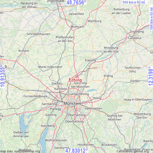
Eching GPS coordinates[2]
48° 18' 0" North, 11° 37' 0.012" East
| Map corner | latitude | longitude |
|---|---|---|
| Upper-left | 48.7656°, | 10.91355° |
| Center: | 48.3°, | 11.61667° |
| Lower-right: | 47.83012°, | 12.3198° |
| Map W x H: | 104×104 km | = 64.6×64.6mi |
| max Lat: | 55.01917° ⇑91.2% North |
| Eching: | 48.3° |
| min Lat: | ⇓8.8% South 47.40724° |
| min Long | Eching | max Long |
| 5.92978° | 11.61667° | 14.98853° |
| W 76%⇐ | ⇒24% E |
Elevation
Elevation of Eching is 467 m = 1532 ft, and this is 217.9 m = 715 ft above average elevation for this country.
| Max E: |
1256 m = 4121 ft | 15.2% |
| Eching | 467 m 1532 ft | |
| Avg. | 249.1 m = 817 ft | |
Min E: |
-5 m = -16 ft | 84.8% |
See also: Germany elevation on elevation.city.
Geographical zone
Eching is located in North temperate zone (between Tropic of Cancer and the Arctic Circle). Distance of this North polar circle is 2030.7 km =1261.8 mi to North.| Distance of | km | miles | from Eching |
|---|---|---|---|
| North Pole | 4636.6 | 2881 | to North |
| Arctic Circle | 2030.7 | 1261.8 | to North |
| Tropic Cancer | 2764.5 | 1717.8 | to South |
| Equator | 5370.5 | 3337.1 | to South |


Nearby cities:
15 places around Eching: (largest is in red/bold)
• Eichenried
12.5 km =7.8 mi,  101°
101°
• Fahrenzhausen
7.5 km =4.7 mi,  322°
322°
• Garching bei München
6.2 km =3.9 mi,  155°
155°
• Haimhausen
4.9 km =3 mi,  290°
290°
• Hallbergmoos
10.4 km =6.5 mi,  72°
72°
• Hebertshausen
11.3 km =7 mi,  264°
264°
• Ismaning
8.9 km =5.5 mi,  146°
146°
• Karlsfeld
13.2 km =8.2 mi,  232°
232°
• Kranzberg
11.8 km =7.3 mi,  358°
358°
• Neufahrn bei Freising
3.9 km =2.4 mi,  62°
62°
• Oberschleißheim
6.7 km =4.2 mi,  213°
213°
• Röhrmoos
13 km =8.1 mi,  284°
284°
• Unterföhring
12.1 km =7.5 mi,  170°
170°
• Unterschleißheim
3.7 km =2.3 mi, 233°
• Vierkirchen
13.3 km =8.3 mi,  303°
303°
Sources, notices
• [Note1] Compared only with cities in Germany existing in our database
• [Src1] Map data: © OpenStreetMap contributors (CC-BY-SA)
• [Src2] Other city data from geonames.org with taken over terms of usage.
• [Src3] Geographical zone / Annual Mean Temperature by Robert A. Rohde @ Wikipedia
