Unterföhring geodata
Unterföhring (Bavaria) is a seat of a fourth-order administrative division; located in Germany in Europe/Berlin (GMT+2) time zone. With population of 10,500 people, there are 1570 cities with bigger population in this country. Compared to other cities in Germany, 92.8% of cities are located further ↑North; 76.4% of cities are located further ←West and 89.2% of cities have lower elevation than Unterföhring. Note1
Administrative division(s):
- Level 1: Bavaria
- Level 2: Upper Bavaria
- Level 3: Landkreis München
- Level 4: Unterföhring


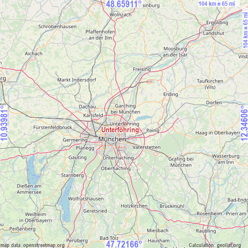
Unterföhring GPS coordinates[2]
48° 11' 33.108" North, 11° 38' 34.548" East
| Map corner | latitude | longitude |
|---|---|---|
| Upper-left | 48.65911°, | 10.93981° |
| Center: | 48.19253°, | 11.64293° |
| Lower-right: | 47.72166°, | 12.34606° |
| Map W x H: | 104.2×104.2 km | = 64.7×64.7mi |
| max Lat: | 55.01917° ⇑92.8% North |
| Unterföhring: | 48.19253° |
| min Lat: | ⇓7.2% South 47.40724° |
| min Long | Unterföhring | max Long |
| 5.92978° | 11.64293° | 14.98853° |
| W 76.4%⇐ | ⇒23.6% E |
Elevation
Elevation of Unterföhring is 505 m = 1657 ft, and this is 255.9 m = 840 ft above average elevation for this country.
| Max E: |
1256 m = 4121 ft | 10.8% |
| Unterföhring | 505 m 1657 ft | |
| Avg. | 249.1 m = 817 ft | |
Min E: |
-5 m = -16 ft | 89.2% |
See also: Germany elevation on elevation.city.
Geographical zone
Unterföhring is located in North temperate zone (between Tropic of Cancer and the Arctic Circle). Distance of this North polar circle is 2042.7 km =1269.3 mi to North.| Distance of | km | miles | from Unterföhring |
|---|---|---|---|
| North Pole | 4648.6 | 2888.5 | to North |
| Arctic Circle | 2042.7 | 1269.3 | to North |
| Tropic Cancer | 2752.6 | 1710.4 | to South |
| Equator | 5358.5 | 3329.6 | to South |


Nearby cities:
15 places around Unterföhring: (largest is in red/bold)
• Aschheim
6 km =3.7 mi,  113°
113°
• Bogenhausen
4.9 km =3 mi,  204°
204°
• Eching
12.1 km =7.5 mi,  350°
350°
• Feldkirchen
8.2 km =5.1 mi,  127°
127°
• Garching bei München
6.3 km =3.9 mi,  5°
5°
• Haar
11.2 km =7 mi,  146°
146°
• Ismaning
5.4 km =3.4 mi,  33°
33°
• Karlsfeld
13 km =8.1 mi,  287°
287°
• Kirchheim bei München
8.5 km =5.3 mi,  101°
101°
• Munich
7.9 km =4.9 mi,  219°
219°
• Neubiberg
12.9 km =8 mi,  174°
174°
• Oberschleißheim
8.5 km =5.3 mi,  318°
318°
• Pliening
11.7 km =7.3 mi,  88°
88°
• Poing
13.3 km =8.3 mi, 100°
• Unterschleißheim
10.9 km =6.8 mi,  333°
333°
Sources, notices
• [Note1] Compared only with cities in Germany existing in our database
• [Src1] Map data: © OpenStreetMap contributors (CC-BY-SA)
• [Src2] Other city data from geonames.org with taken over terms of usage.
• [Src3] Geographical zone / Annual Mean Temperature by Robert A. Rohde @ Wikipedia
