Drangstedt geodata
Drangstedt (Lower Saxony) is a seat of a fourth-order administrative division; located in Germany in Europe/Berlin (GMT+2) time zone. With population of 1,467 people, there are 5944 cities with bigger population in this country. Compared to other cities in Germany, 87.2% of cities are located further ↓South; 68.5% of cities are located further →East and 93.1% of cities have higher elevation than Drangstedt. Note1


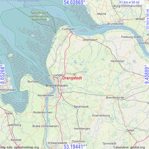
Drangstedt GPS coordinates[2]
53° 36' 48.924" North, 8° 45' 20.736" East
| Map corner | latitude | longitude |
|---|---|---|
| Upper-left | 54.02865°, | 8.05264° |
| Center: | 53.61359°, | 8.75576° |
| Lower-right: | 53.19441°, | 9.45889° |
| Map W x H: | 92.8×92.8 km | = 57.7×57.7mi |
| max Lat: | 55.01917° ⇑12.8% North |
| Drangstedt: | 53.61359° |
| min Lat: | ⇓87.2% South 47.40724° |
| min Long | Drangstedt | max Long |
| 5.92978° | 8.75576° | 14.98853° |
| W 31.5%⇐ | ⇒68.5% E |
Elevation
Elevation of Drangstedt is 13 m = 43 ft, and this is 236.1 m = 775 ft below average elevation for this country.
| Max E: |
1256 m = 4121 ft | 93.1% |
| Avg. | 249.1 m = 817 ft | |
| Drangstedt | 13 m = 43 ft | |
Min E: |
-5 m = -16 ft | 6.9% |
See also: Germany elevation on elevation.city.
Geographical zone
Drangstedt is located in North temperate zone (between Tropic of Cancer and the Arctic Circle). Distance of this North polar circle is 1439.9 km =894.7 mi to North.| Distance of | km | miles | from Drangstedt |
|---|---|---|---|
| North Pole | 4045.8 | 2513.9 | to North |
| Arctic Circle | 1439.9 | 894.7 | to North |
| Tropic Cancer | 3355.4 | 2084.9 | to South |
| Equator | 5961.3 | 3704.2 | to South |


Nearby cities:
15 places around Drangstedt: (largest is in red/bold)
• Bremerhaven
13.8 km =8.6 mi,  239°
239°
• Dorum
14.9 km =9.3 mi,  303°
303°
• Elmlohe
3.1 km =1.9 mi,  196°
196°
• Flögeln
6.2 km =3.9 mi,  31°
31°
• Köhlen
11.3 km =7 mi,  135°
135°
• Kührstedt
5 km =3.1 mi, 143°
• Langen
10.6 km =6.6 mi,  265°
265°
• Lintig
8.2 km =5.1 mi,  97°
97°
• Mulsum
14.8 km =9.2 mi,  293°
293°
• Odisheim
15.3 km =9.5 mi,  53°
53°
• Ringstedt
8.5 km =5.3 mi,  133°
133°
• Schiffdorf
11.3 km =7 mi,  218°
218°
• Steinau
11.4 km =7.1 mi, 47°
• Stinstedt
15.2 km =9.4 mi,  69°
69°
• Wanna
15.4 km =9.6 mi,  10°
10°
Sources, notices
• [Note1] Compared only with cities in Germany existing in our database
• [Src1] Map data: © OpenStreetMap contributors (CC-BY-SA)
• [Src2] Other city data from geonames.org with taken over terms of usage.
• [Src3] Geographical zone / Annual Mean Temperature by Robert A. Rohde @ Wikipedia
