Krautheim geodata
Krautheim (Baden-Württemberg) is a populated place; located in Germany in Europe/Berlin (GMT+2) time zone. With population of 4,884 people, there are 2864 cities with bigger population in this country. Compared to other cities in Germany, 77.3% of cities are located further ↑North; 55.5% of cities are located further →East and 62.5% of cities have lower elevation than Krautheim. Note1
Administrative division(s):
- Level 1: Baden-Württemberg
- Level 2: Regierungsbezirk Stuttgart
- Level 3: Hohenlohekreis
- Level 4: Krautheim


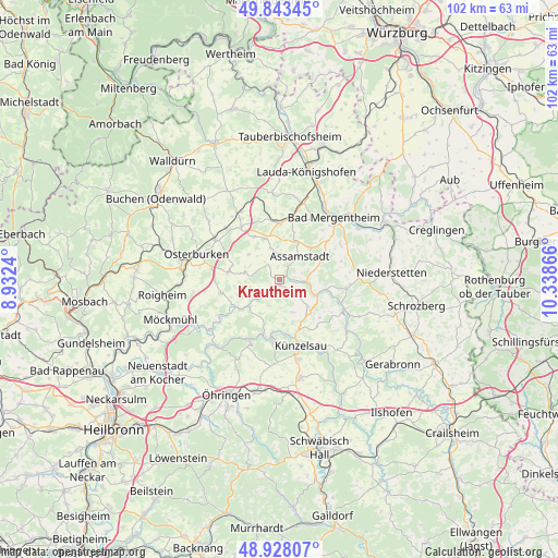
Krautheim GPS coordinates[2]
49° 23' 16.404" North, 9° 38' 7.908" East
| Map corner | latitude | longitude |
|---|---|---|
| Upper-left | 49.84345°, | 8.9324° |
| Center: | 49.38789°, | 9.63553° |
| Lower-right: | 48.92807°, | 10.33866° |
| Map W x H: | 101.8×101.8 km | = 63.3×63.3mi |
| max Lat: | 55.01917° ⇑77.3% North |
| Krautheim: | 49.38789° |
| min Lat: | ⇓22.7% South 47.40724° |
| min Long | Krautheim | max Long |
| 5.92978° | 9.63553° | 14.98853° |
| W 44.5%⇐ | ⇒55.5% E |
Elevation
Elevation of Krautheim is 305 m = 1001 ft, and this is 55.9 m = 183 ft above average elevation for this country.
| Max E: |
1256 m = 4121 ft | 37.5% |
| Krautheim | 305 m 1001 ft | |
| Avg. | 249.1 m = 817 ft | |
Min E: |
-5 m = -16 ft | 62.5% |
See also: Germany elevation on elevation.city.
Geographical zone
Krautheim is located in North temperate zone (between Tropic of Cancer and the Arctic Circle). Distance of this North polar circle is 1909.8 km =1186.7 mi to North.| Distance of | km | miles | from Krautheim |
|---|---|---|---|
| North Pole | 4515.6 | 2805.9 | to North |
| Arctic Circle | 1909.8 | 1186.7 | to North |
| Tropic Cancer | 2885.5 | 1793 | to South |
| Equator | 5491.4 | 3412.2 | to South |


Nearby cities:
15 places around Krautheim: (largest is in red/bold)
• Assamstadt
5.8 km =3.6 mi,  39°
39°
• Bad Mergentheim
15.3 km =9.5 mi, 40°
• Boxberg
10.2 km =6.3 mi,  1°
1°
• Dörzbach
5.2 km =3.2 mi,  95°
95°
• Forchtenberg
12.3 km =7.6 mi,  206°
206°
• Ingelfingen
9.8 km =6.1 mi,  172°
172°
• Jagsthausen
14.9 km =9.3 mi,  234°
234°
• Künzelsau
12.3 km =7.6 mi,  163°
163°
• Mulfingen
13.1 km =8.1 mi,  113°
113°
• Niedernhall
10.4 km =6.5 mi,  187°
187°
• Osterburken
16.1 km =10 mi,  286°
286°
• Rosenberg
14 km =8.7 mi,  302°
302°
• Weißbach
10.5 km =6.5 mi,  196°
196°
• Widdern
17.3 km =10.7 mi,  243°
243°
• Zweiflingen
16.9 km =10.5 mi, 210°
Sources, notices
• [Note1] Compared only with cities in Germany existing in our database
• [Src1] Map data: © OpenStreetMap contributors (CC-BY-SA)
• [Src2] Other city data from geonames.org with taken over terms of usage.
• [Src3] Geographical zone / Annual Mean Temperature by Robert A. Rohde @ Wikipedia
