Frontenhausen geodata
Frontenhausen (Bavaria) is a populated place; located in Germany in Europe/Berlin (GMT+2) time zone. With population of 4,430 people, there are 3073 cities with bigger population in this country. Compared to other cities in Germany, 88.5% of cities are located further ↑North; 88.2% of cities are located further ←West and 77.2% of cities have lower elevation than Frontenhausen. Note1
Administrative division(s):
- Level 1: Bavaria
- Level 2: Lower Bavaria
- Level 3: Landkreis Dingolfing-Landau
- Level 4: Frontenhausen, Markt


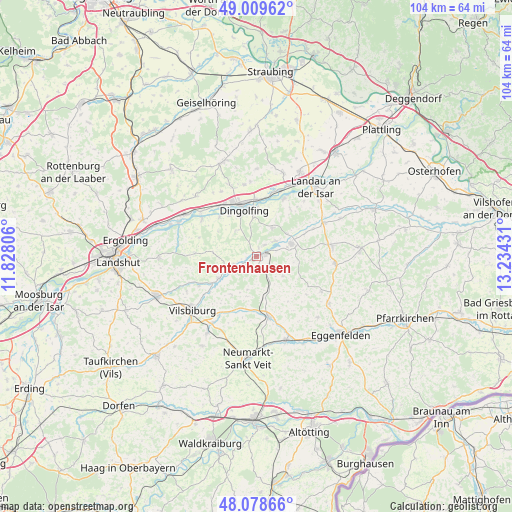
Frontenhausen GPS coordinates[2]
48° 32' 46.608" North, 12° 31' 52.248" East
| Map corner | latitude | longitude |
|---|---|---|
| Upper-left | 49.00962°, | 11.82806° |
| Center: | 48.54628°, | 12.53118° |
| Lower-right: | 48.07866°, | 13.23431° |
| Map W x H: | 103.5×103.5 km | = 64.3×64.3mi |
| max Lat: | 55.01917° ⇑88.5% North |
| Frontenhausen: | 48.54628° |
| min Lat: | ⇓11.5% South 47.40724° |
| min Long | Frontenhausen | max Long |
| 5.92978° | 12.53118° | 14.98853° |
| W 88.2%⇐ | ⇒11.8% E |
Elevation
Elevation of Frontenhausen is 414 m = 1358 ft, and this is 164.9 m = 541 ft above average elevation for this country.
| Max E: |
1256 m = 4121 ft | 22.8% |
| Frontenhausen | 414 m 1358 ft | |
| Avg. | 249.1 m = 817 ft | |
Min E: |
-5 m = -16 ft | 77.2% |
See also: Germany elevation on elevation.city.
Geographical zone
Frontenhausen is located in North temperate zone (between Tropic of Cancer and the Arctic Circle). Distance of this North polar circle is 2003.3 km =1244.8 mi to North.| Distance of | km | miles | from Frontenhausen |
|---|---|---|---|
| North Pole | 4609.2 | 2864 | to North |
| Arctic Circle | 2003.3 | 1244.8 | to North |
| Tropic Cancer | 2791.9 | 1734.8 | to South |
| Equator | 5397.8 | 3354 | to South |


Nearby cities:
15 places around Frontenhausen: (largest is in red/bold)
• Aham
5.6 km =3.5 mi,  247°
247°
• Dingolfing
11.1 km =6.9 mi,  345°
345°
• Gangkofen
12.4 km =7.7 mi,  168°
168°
• Gerzen
8.8 km =5.5 mi,  240°
240°
• Gottfrieding
10.1 km =6.3 mi,  1°
1°
• Loiching
10.6 km =6.6 mi,  317°
317°
• Mamming
13 km =8.1 mi,  25°
25°
• Marklkofen
2.6 km =1.6 mi,  81°
81°
• Moosthenning
14.7 km =9.1 mi, 350°
• Niederviehbach
13.4 km =8.3 mi,  305°
305°
• Reisbach
7.6 km =4.7 mi,  69°
69°
• Rimbach
12.4 km =7.7 mi,  135°
135°
• Ruhstorf
11.2 km =7 mi,  93°
93°
• Schalkham
11 km =6.8 mi,  230°
230°
• Simbach
15.4 km =9.6 mi, 81°
Sources, notices
• [Note1] Compared only with cities in Germany existing in our database
• [Src1] Map data: © OpenStreetMap contributors (CC-BY-SA)
• [Src2] Other city data from geonames.org with taken over terms of usage.
• [Src3] Geographical zone / Annual Mean Temperature by Robert A. Rohde @ Wikipedia
