Beckingen geodata
Beckingen (Saarland) is a seat of a fourth-order administrative division; located in Germany in Europe/Berlin (GMT+2) time zone. With population of 15,983 people, there are 1004 cities with bigger population in this country. Compared to other cities in Germany, 77.2% of cities are located further ↑North; 96.4% of cities are located further →East and 51.3% of cities have higher elevation than Beckingen. Note1


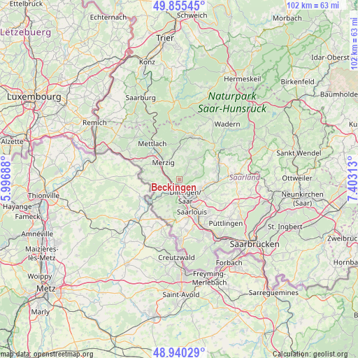
Beckingen GPS coordinates[2]
49° 24' 0" North, 6° 42' 0" East
| Map corner | latitude | longitude |
|---|---|---|
| Upper-left | 49.85545°, | 5.99688° |
| Center: | 49.4°, | 6.7° |
| Lower-right: | 48.94029°, | 7.40313° |
| Map W x H: | 101.8×101.8 km | = 63.3×63.3mi |
| max Lat: | 55.01917° ⇑77.2% North |
| Beckingen: | 49.4° |
| min Lat: | ⇓22.8% South 47.40724° |
| min Long | Beckingen | max Long |
| 5.92978° | 6.7° | 14.98853° |
| W 3.6%⇐ | ⇒96.4% E |
Elevation
Elevation of Beckingen is 216 m = 709 ft, and this is 33.1 m = 109 ft below average elevation for this country.
| Max E: |
1256 m = 4121 ft | 51.3% |
| Avg. | 249.1 m = 817 ft | |
| Beckingen | 216 m = 709 ft | |
Min E: |
-5 m = -16 ft | 48.7% |
See also: Germany elevation on elevation.city.
Geographical zone
Beckingen is located in North temperate zone (between Tropic of Cancer and the Arctic Circle). Distance of this North polar circle is 1908.4 km =1185.8 mi to North.| Distance of | km | miles | from Beckingen |
|---|---|---|---|
| North Pole | 4514.3 | 2805.1 | to North |
| Arctic Circle | 1908.4 | 1185.8 | to North |
| Tropic Cancer | 2886.8 | 1793.8 | to South |
| Equator | 5492.8 | 3413.1 | to South |


Nearby cities:
15 places around Beckingen: (largest is in red/bold)
• Altforweiler
14 km =8.7 mi,  178°
178°
• Berus
15.1 km =9.4 mi, 181°
• Britten
13.5 km =8.4 mi,  352°
352°
• Dillingen
5.3 km =3.3 mi,  157°
157°
• Ensdorf
12.7 km =7.9 mi,  151°
151°
• Losheim
12.7 km =7.9 mi,  15°
15°
• Merzig
6.5 km =4 mi,  317°
317°
• Mettlach
13.4 km =8.3 mi, 321°
• Nalbach
6.3 km =3.9 mi,  107°
107°
• Saarhölzbach
14.5 km =9 mi,  332°
332°
• Saarlouis
10.3 km =6.4 mi, 158°
• Saarwellingen
9.1 km =5.7 mi,  123°
123°
• Schmelz
11.5 km =7.1 mi,  71°
71°
• Schwalbach
14 km =8.7 mi,  142°
142°
• Wallerfangen
8.1 km =5 mi,  174°
174°
Sources, notices
• [Note1] Compared only with cities in Germany existing in our database
• [Src1] Map data: © OpenStreetMap contributors (CC-BY-SA)
• [Src2] Other city data from geonames.org with taken over terms of usage.
• [Src3] Geographical zone / Annual Mean Temperature by Robert A. Rohde @ Wikipedia
