Merzig geodata
Merzig (Saarland) is a seat of a third-order administrative division; located in Germany in Europe/Berlin (GMT+2) time zone. With population of 31,118 people, there are 447 cities with bigger population in this country. Compared to other cities in Germany, 76.6% of cities are located further ↑North; 96.8% of cities are located further →East and 56.7% of cities have higher elevation than Merzig. Note1
Administrative division(s):
- Level 1: Saarland
- Level 3: Landkreis Merzig-Wadern
- Level 4: Merzig, Kreisstadt


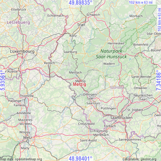
Merzig GPS coordinates[2]
49° 26' 35.916" North, 6° 38' 19.464" East
| Map corner | latitude | longitude |
|---|---|---|
| Upper-left | 49.89835°, | 5.93561° |
| Center: | 49.44331°, | 6.63874° |
| Lower-right: | 48.98401°, | 7.34186° |
| Map W x H: | 101.7×101.7 km | = 63.2×63.2mi |
| max Lat: | 55.01917° ⇑76.6% North |
| Merzig: | 49.44331° |
| min Lat: | ⇓23.4% South 47.40724° |
| min Long | Merzig | max Long |
| 5.92978° | 6.63874° | 14.98853° |
| W 3.2%⇐ | ⇒96.8% E |
Elevation
Elevation of Merzig is 177 m = 581 ft, and this is 72.1 m = 237 ft below average elevation for this country.
| Max E: |
1256 m = 4121 ft | 56.7% |
| Avg. | 249.1 m = 817 ft | |
| Merzig | 177 m = 581 ft | |
Min E: |
-5 m = -16 ft | 43.3% |
See also: Germany elevation on elevation.city.
Geographical zone
Merzig is located in North temperate zone (between Tropic of Cancer and the Arctic Circle). Distance of this North polar circle is 1903.6 km =1182.8 mi to North.| Distance of | km | miles | from Merzig |
|---|---|---|---|
| North Pole | 4509.5 | 2802.1 | to North |
| Arctic Circle | 1903.6 | 1182.8 | to North |
| Tropic Cancer | 2891.7 | 1796.8 | to South |
| Equator | 5497.6 | 3416 | to South |


Nearby cities:
15 places around Merzig: (largest is in red/bold)
• Beckingen
6.5 km =4 mi,  137°
137°
• Britten
9 km =5.6 mi,  17°
17°
• Dillingen
11.7 km =7.3 mi,  146°
146°
• Freudenburg
13.5 km =8.4 mi,  325°
325°
• Greimerath
13.5 km =8.4 mi,  13°
13°
• Kastel-Staadt
14.7 km =9.1 mi,  337°
337°
• Losheim
10.7 km =6.6 mi,  46°
46°
• Mettlach
6.9 km =4.3 mi, 326°
• Nalbach
12.4 km =7.7 mi,  122°
122°
• Orscholz
10.8 km =6.7 mi,  310°
310°
• Saarhölzbach
8.4 km =5.2 mi, 344°
• Schmelz
15.3 km =9.5 mi,  94°
94°
• Taben-Rodt
12.5 km =7.8 mi, 341°
• Wallerfangen
13.9 km =8.6 mi,  157°
157°
• Weiten
12 km =7.5 mi,  323°
323°
Sources, notices
• [Note1] Compared only with cities in Germany existing in our database
• [Src1] Map data: © OpenStreetMap contributors (CC-BY-SA)
• [Src2] Other city data from geonames.org with taken over terms of usage.
• [Src3] Geographical zone / Annual Mean Temperature by Robert A. Rohde @ Wikipedia
