Belau geodata
Belau (Schleswig-Holstein) is a seat of a fourth-order administrative division; located in Germany in Europe/Berlin (GMT+2) time zone. With population of 331 people, there are 9937 cities with bigger population in this country. Compared to other cities in Germany, 93.8% of cities are located further ↓South; 54.5% of cities are located further ←West and 83.2% of cities have higher elevation than Belau. Note1


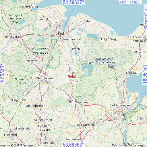
Belau GPS coordinates[2]
54° 5' 52.8" North, 10° 15' 30.528" East
| Map corner | latitude | longitude |
|---|---|---|
| Upper-left | 54.50827°, | 9.55535° |
| Center: | 54.098°, | 10.25848° |
| Lower-right: | 53.68363°, | 10.96161° |
| Map W x H: | 91.7×91.7 km | = 57×57mi |
| max Lat: | 55.01917° ⇑6.2% North |
| Belau: | 54.098° |
| min Lat: | ⇓93.8% South 47.40724° |
| min Long | Belau | max Long |
| 5.92978° | 10.25848° | 14.98853° |
| W 54.5%⇐ | ⇒45.5% E |
Elevation
Elevation of Belau is 39 m = 128 ft, and this is 210.1 m = 689 ft below average elevation for this country.
| Max E: |
1256 m = 4121 ft | 83.2% |
| Avg. | 249.1 m = 817 ft | |
| Belau | 39 m = 128 ft | |
Min E: |
-5 m = -16 ft | 16.8% |
See also: Germany elevation on elevation.city.
Geographical zone
Belau is located in North temperate zone (between Tropic of Cancer and the Arctic Circle). Distance of this North polar circle is 1386 km =861.2 mi to North.| Distance of | km | miles | from Belau |
|---|---|---|---|
| North Pole | 3991.9 | 2480.5 | to North |
| Arctic Circle | 1386 | 861.2 | to North |
| Tropic Cancer | 3409.2 | 2118.4 | to South |
| Equator | 6015.1 | 3737.6 | to South |


Nearby cities:
15 places around Belau: (largest is in red/bold)
• Ascheberg
8.1 km =5 mi,  44°
44°
• Bornhöved
3.9 km =2.4 mi,  205°
205°
• Damsdorf
5.2 km =3.2 mi,  132°
132°
• Dersau
5.4 km =3.4 mi,  65°
65°
• Gönnebek
6.8 km =4.2 mi,  216°
216°
• Kalübbe
2.6 km =1.6 mi, 37°
• Rendswühren
5.2 km =3.2 mi,  251°
251°
• Ruhwinkel
2.7 km =1.7 mi,  274°
274°
• Schmalensee
1.8 km =1.1 mi,  154°
154°
• Stocksee
5.5 km =3.4 mi,  99°
99°
• Stolpe
4.8 km =3 mi,  325°
325°
• Tarbek
5.4 km =3.4 mi,  174°
174°
• Tensfeld
7.3 km =4.5 mi, 147°
• Trappenkamp
7.1 km =4.4 mi,  203°
203°
• Wankendorf
3.8 km =2.4 mi,  294°
294°
Sources, notices
• [Note1] Compared only with cities in Germany existing in our database
• [Src1] Map data: © OpenStreetMap contributors (CC-BY-SA)
• [Src2] Other city data from geonames.org with taken over terms of usage.
• [Src3] Geographical zone / Annual Mean Temperature by Robert A. Rohde @ Wikipedia
