Sprakensehl geodata
Sprakensehl (Lower Saxony) is a seat of a fourth-order administrative division; located in Germany in Europe/Berlin (GMT+2) time zone. With population of 1,313 people, there are 6270 cities with bigger population in this country. Compared to other cities in Germany, 80.2% of cities are located further ↓South; 58.8% of cities are located further ←West and 66.3% of cities have higher elevation than Sprakensehl. Note1


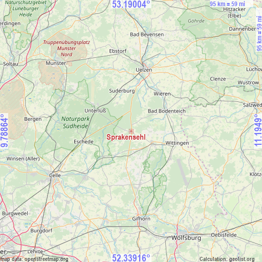
Sprakensehl GPS coordinates[2]
52° 46' 0.048" North, 10° 29' 30.372" East
| Map corner | latitude | longitude |
|---|---|---|
| Upper-left | 53.19004°, | 9.78864° |
| Center: | 52.76668°, | 10.49177° |
| Lower-right: | 52.33916°, | 11.1949° |
| Map W x H: | 94.6×94.6 km | = 58.8×58.8mi |
| max Lat: | 55.01917° ⇑19.8% North |
| Sprakensehl: | 52.76668° |
| min Lat: | ⇓80.2% South 47.40724° |
| min Long | Sprakensehl | max Long |
| 5.92978° | 10.49177° | 14.98853° |
| W 58.8%⇐ | ⇒41.2% E |
Elevation
Elevation of Sprakensehl is 112 m = 367 ft, and this is 137.1 m = 450 ft below average elevation for this country.
| Max E: |
1256 m = 4121 ft | 66.3% |
| Avg. | 249.1 m = 817 ft | |
| Sprakensehl | 112 m = 367 ft | |
Min E: |
-5 m = -16 ft | 33.7% |
See also: Germany elevation on elevation.city.
Geographical zone
Sprakensehl is located in North temperate zone (between Tropic of Cancer and the Arctic Circle). Distance of this North polar circle is 1534.1 km =953.2 mi to North.| Distance of | km | miles | from Sprakensehl |
|---|---|---|---|
| North Pole | 4140 | 2572.5 | to North |
| Arctic Circle | 1534.1 | 953.2 | to North |
| Tropic Cancer | 3261.2 | 2026.4 | to South |
| Equator | 5867.1 | 3645.6 | to South |


Nearby cities:
15 places around Sprakensehl: (largest is in red/bold)
• Bodenteich
14.6 km =9.1 mi,  60°
60°
• Dedelstorf
7.4 km =4.6 mi,  175°
175°
• Eldingen
14.1 km =8.8 mi,  229°
229°
• Groß Oesingen
13.4 km =8.3 mi,  188°
188°
• Hankensbüttel
8.2 km =5.1 mi,  116°
116°
• Lüder
12.6 km =7.8 mi,  68°
68°
• Obernholz
7.1 km =4.4 mi,  90°
90°
• Scharnhorst
15.1 km =9.4 mi,  248°
248°
• Stadensen
12.9 km =8 mi,  19°
19°
• Steinhorst
11.1 km =6.9 mi,  213°
213°
• Suderburg
14.6 km =9.1 mi,  349°
349°
• Unterlüß
15.1 km =9.4 mi,  299°
299°
• Wieren
17.3 km =10.7 mi,  40°
40°
• Wittingen
17 km =10.6 mi,  105°
105°
• Wrestedt
16.3 km =10.1 mi, 20°
Sources, notices
• [Note1] Compared only with cities in Germany existing in our database
• [Src1] Map data: © OpenStreetMap contributors (CC-BY-SA)
• [Src2] Other city data from geonames.org with taken over terms of usage.
• [Src3] Geographical zone / Annual Mean Temperature by Robert A. Rohde @ Wikipedia
