Crinitz geodata
Crinitz (Brandenburg) is a seat of a fourth-order administrative division; located in Germany in Europe/Berlin (GMT+2) time zone. With population of 1,504 people, there are 5872 cities with bigger population in this country. Compared to other cities in Germany, 69.2% of cities are located further ↓South; 97.2% of cities are located further ←West and 63.5% of cities have higher elevation than Crinitz. Note1


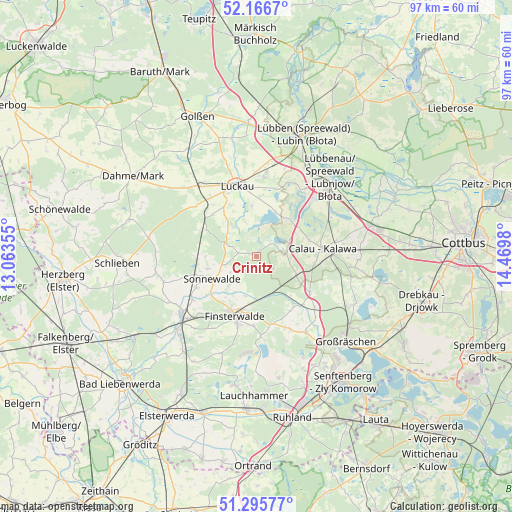
Crinitz GPS coordinates[2]
51° 43' 59.988" North, 13° 46' 0.012" East
| Map corner | latitude | longitude |
|---|---|---|
| Upper-left | 52.1667°, | 13.06355° |
| Center: | 51.73333°, | 13.76667° |
| Lower-right: | 51.29577°, | 14.4698° |
| Map W x H: | 96.8×96.8 km | = 60.1×60.1mi |
| max Lat: | 55.01917° ⇑30.8% North |
| Crinitz: | 51.73333° |
| min Lat: | ⇓69.2% South 47.40724° |
| min Long | Crinitz | max Long |
| 5.92978° | 13.76667° | 14.98853° |
| W 97.2%⇐ | ⇒2.8% E |
Elevation
Elevation of Crinitz is 129 m = 423 ft, and this is 120.1 m = 394 ft below average elevation for this country.
| Max E: |
1256 m = 4121 ft | 63.5% |
| Avg. | 249.1 m = 817 ft | |
| Crinitz | 129 m = 423 ft | |
Min E: |
-5 m = -16 ft | 36.5% |
See also: Germany elevation on elevation.city.
Geographical zone
Crinitz is located in North temperate zone (between Tropic of Cancer and the Arctic Circle). Distance of this North polar circle is 1649 km =1024.6 mi to North.| Distance of | km | miles | from Crinitz |
|---|---|---|---|
| North Pole | 4254.9 | 2643.9 | to North |
| Arctic Circle | 1649 | 1024.6 | to North |
| Tropic Cancer | 3146.3 | 1955 | to South |
| Equator | 5752.2 | 3574.3 | to South |


Nearby cities:
15 places around Crinitz: (largest is in red/bold)
• Altdöbern
20.6 km =12.8 mi,  116°
116°
• Bronkow
12.7 km =7.9 mi,  125°
125°
• Calau
12.9 km =8 mi,  84°
84°
• Doberlug-Kirchhain
18.5 km =11.5 mi,  229°
229°
• Finsterwalde
11.8 km =7.3 mi,  200°
200°
• Hohenbucko
21 km =13 mi,  280°
280°
• Kasel-Golzig
22.7 km =14.1 mi,  348°
348°
• Lichterfeld
15.1 km =9.4 mi,  177°
177°
• Luckau
13.9 km =8.6 mi,  342°
342°
• Lübbenau
19.2 km =11.9 mi,  41°
41°
• Rückersdorf
22.6 km =14 mi,  216°
216°
• Sallgast
17 km =10.6 mi,  160°
160°
• Schönewalde
12.8 km =8 mi,  241°
241°
• Sonnewalde
9.4 km =5.8 mi, 240°
• Vetschau
22.3 km =13.9 mi,  74°
74°
Sources, notices
• [Note1] Compared only with cities in Germany existing in our database
• [Src1] Map data: © OpenStreetMap contributors (CC-BY-SA)
• [Src2] Other city data from geonames.org with taken over terms of usage.
• [Src3] Geographical zone / Annual Mean Temperature by Robert A. Rohde @ Wikipedia
