Doberlug-Kirchhain geodata
Doberlug-Kirchhain (Brandenburg) is a populated place; located in Germany in Europe/Berlin (GMT+2) time zone. With population of 10,151 people, there are 1613 cities with bigger population in this country. Compared to other cities in Germany, 68% of cities are located further ↓South; 96.1% of cities are located further ←West and 68.5% of cities have higher elevation than Doberlug-Kirchhain. Note1
Administrative division(s):
- Level 1: Brandenburg
- Level 3: Landkreis Elbe-Elster
- Level 4: Doberlug-Kirchhain


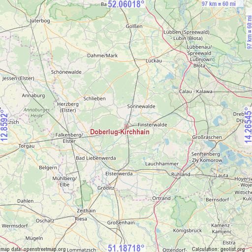
Doberlug-Kirchhain GPS coordinates[2]
51° 37' 32.808" North, 13° 33' 44.352" East
| Map corner | latitude | longitude |
|---|---|---|
| Upper-left | 52.06018°, | 12.8592° |
| Center: | 51.62578°, | 13.56232° |
| Lower-right: | 51.18718°, | 14.26545° |
| Map W x H: | 97.1×97.1 km | = 60.3×60.3mi |
| max Lat: | 55.01917° ⇑32% North |
| Doberlug-Kirchhain: | 51.62578° |
| min Lat: | ⇓68% South 47.40724° |
| min Long | Doberlug-Kirchh | max Long |
| 5.92978° | 13.56232° | 14.98853° |
| W 96.1%⇐ | ⇒3.9% E |
Elevation
Elevation of Doberlug-Kirchhain is 100 m = 328 ft, and this is 149.1 m = 489 ft below average elevation for this country.
| Max E: |
1256 m = 4121 ft | 68.5% |
| Avg. | 249.1 m = 817 ft | |
| Doberlug-Kirchhain | 100 m = 328 ft | |
Min E: |
-5 m = -16 ft | 31.5% |
See also: Germany elevation on elevation.city.
Geographical zone
Doberlug-Kirchhain is located in North temperate zone (between Tropic of Cancer and the Arctic Circle). Distance of this North polar circle is 1660.9 km =1032 mi to North.| Distance of | km | miles | from Doberlug-Kirchhain |
|---|---|---|---|
| North Pole | 4266.8 | 2651.3 | to North |
| Arctic Circle | 1660.9 | 1032 | to North |
| Tropic Cancer | 3134.3 | 1947.6 | to South |
| Equator | 5740.2 | 3566.8 | to South |


Nearby cities:
15 places around Doberlug-Kirchhain: (largest is in red/bold)
• Bad Liebenwerda
16.7 km =10.4 mi,  224°
224°
• Crinitz
18.5 km =11.5 mi,  49°
49°
• Finsterwalde
10 km =6.2 mi,  84°
84°
• Hohenbucko
17 km =10.6 mi,  337°
337°
• Hohenleipisch
14 km =8.7 mi,  183°
183°
• Lichterfeld
15.2 km =9.4 mi,  101°
101°
• Plessa
18.1 km =11.2 mi,  168°
168°
• Rückersdorf
6.3 km =3.9 mi, 173°
• Schilda
12.7 km =7.9 mi,  256°
256°
• Schlieben
16.5 km =10.3 mi,  311°
311°
• Schönborn
5.8 km =3.6 mi,  240°
240°
• Schönewalde
6.5 km =4 mi,  25°
25°
• Sonnewalde
9.4 km =5.8 mi,  38°
38°
• Tröbitz
9.4 km =5.8 mi,  252°
252°
• Uebigau
18.5 km =11.5 mi, 259°
Sources, notices
• [Note1] Compared only with cities in Germany existing in our database
• [Src1] Map data: © OpenStreetMap contributors (CC-BY-SA)
• [Src2] Other city data from geonames.org with taken over terms of usage.
• [Src3] Geographical zone / Annual Mean Temperature by Robert A. Rohde @ Wikipedia
