Lichterfeld geodata
Lichterfeld (Brandenburg) is a populated place; located in Germany in Europe/Berlin (GMT+2) time zone. With population of 983 people, there are 7242 cities with bigger population in this country. Compared to other cities in Germany, 67.6% of cities are located further ↓South; 97.2% of cities are located further ←West and 63.9% of cities have higher elevation than Lichterfeld. Note1
Administrative division(s):
- Level 1: Brandenburg
- Level 3: Landkreis Elbe-Elster
- Level 4: Lichterfeld-Schacksdorf


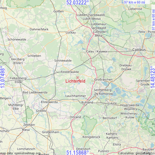
Lichterfeld GPS coordinates[2]
51° 35' 51.18" North, 13° 46' 41.16" East
| Map corner | latitude | longitude |
|---|---|---|
| Upper-left | 52.03222°, | 13.07498° |
| Center: | 51.59755°, | 13.7781° |
| Lower-right: | 51.15868°, | 14.48123° |
| Map W x H: | 97.1×97.1 km | = 60.3×60.3mi |
| max Lat: | 55.01917° ⇑32.4% North |
| Lichterfeld: | 51.59755° |
| min Lat: | ⇓67.6% South 47.40724° |
| min Long | Lichterfeld | max Long |
| 5.92978° | 13.7781° | 14.98853° |
| W 97.2%⇐ | ⇒2.8% E |
Elevation
Elevation of Lichterfeld is 127 m = 417 ft, and this is 122.1 m = 401 ft below average elevation for this country.
| Max E: |
1256 m = 4121 ft | 63.9% |
| Avg. | 249.1 m = 817 ft | |
| Lichterfeld | 127 m = 417 ft | |
Min E: |
-5 m = -16 ft | 36.1% |
See also: Germany elevation on elevation.city.
Geographical zone
Lichterfeld is located in North temperate zone (between Tropic of Cancer and the Arctic Circle). Distance of this North polar circle is 1664.1 km =1034 mi to North.| Distance of | km | miles | from Lichterfeld |
|---|---|---|---|
| North Pole | 4270 | 2653.3 | to North |
| Arctic Circle | 1664.1 | 1034 | to North |
| Tropic Cancer | 3131.2 | 1945.6 | to South |
| Equator | 5737.1 | 3564.9 | to South |


Nearby cities:
15 places around Lichterfeld: (largest is in red/bold)
• Bronkow
12.3 km =7.6 mi,  51°
51°
• Crinitz
15.1 km =9.4 mi,  357°
357°
• Doberlug-Kirchhain
15.2 km =9.4 mi,  281°
281°
• Finsterwalde
6.4 km =4 mi,  309°
309°
• Großräschen
16.1 km =10 mi,  93°
93°
• Lauchhammer
12.2 km =7.6 mi,  183°
183°
• Plessa
18.3 km =11.4 mi,  217°
217°
• Ruhland
16.7 km =10.4 mi,  158°
158°
• Rückersdorf
14.6 km =9.1 mi,  257°
257°
• Sallgast
5 km =3.1 mi,  101°
101°
• Schipkau
12.1 km =7.5 mi,  137°
137°
• Schwarzheide
14.5 km =9 mi, 158°
• Schönewalde
15.1 km =9.4 mi, 306°
• Senftenberg
17.4 km =10.8 mi,  117°
117°
• Sonnewalde
13.9 km =8.6 mi,  319°
319°
Sources, notices
• [Note1] Compared only with cities in Germany existing in our database
• [Src1] Map data: © OpenStreetMap contributors (CC-BY-SA)
• [Src2] Other city data from geonames.org with taken over terms of usage.
• [Src3] Geographical zone / Annual Mean Temperature by Robert A. Rohde @ Wikipedia
