Emden geodata
Emden (Lower Saxony) is a seat of a third-order administrative division; located in Germany in Europe/Berlin (GMT+2) time zone. With population of 51,526 people, there are 214 cities with bigger population in this country. Compared to other cities in Germany, 84.3% of cities are located further ↓South; 91.2% of cities are located further →East and 96.2% of cities have higher elevation than Emden. Note1


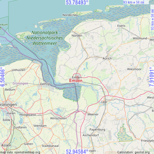
Emden GPS coordinates[2]
53° 22' 2.82" North, 7° 12' 28.008" East
| Map corner | latitude | longitude |
|---|---|---|
| Upper-left | 53.78493°, | 6.50466° |
| Center: | 53.36745°, | 7.20778° |
| Lower-right: | 52.94584°, | 7.91091° |
| Map W x H: | 93.3×93.3 km | = 58×58mi |
| max Lat: | 55.01917° ⇑15.7% North |
| Emden: | 53.36745° |
| min Lat: | ⇓84.3% South 47.40724° |
| min Long | Emden | max Long |
| 5.92978° | 7.20778° | 14.98853° |
| W 8.8%⇐ | ⇒91.2% E |
Elevation
Elevation of Emden is 6 m = 20 ft, and this is 243.1 m = 798 ft below average elevation for this country.
| Max E: |
1256 m = 4121 ft | 96.2% |
| Avg. | 249.1 m = 817 ft | |
| Emden | 6 m = 20 ft | |
Min E: |
-5 m = -16 ft | 3.8% |
See also: Emden elevation on elevation.city.
Geographical zone
Emden is located in North temperate zone (between Tropic of Cancer and the Arctic Circle). Distance of this North polar circle is 1467.3 km =911.7 mi to North.| Distance of | km | miles | from Emden |
|---|---|---|---|
| North Pole | 4073.2 | 2531 | to North |
| Arctic Circle | 1467.3 | 911.7 | to North |
| Tropic Cancer | 3328 | 2067.9 | to South |
| Equator | 5933.9 | 3687.2 | to South |


Nearby cities:
15 places around Emden: (largest is in red/bold)
• Aurich
21.4 km =13.3 mi,  58°
58°
• Bunde
20.8 km =12.9 mi,  169°
169°
• Halbemond
22.9 km =14.2 mi,  13°
13°
• Hinte
5.7 km =3.5 mi,  343°
343°
• Jemgum
16.2 km =10.1 mi,  133°
133°
• Leer
22.6 km =14 mi, 131°
• Leezdorf
21.2 km =13.2 mi,  16°
16°
• Marienhafe
17.8 km =11.1 mi, 14°
• Mittegroßefehn
23.9 km =14.9 mi,  83°
83°
• Neukamperfehn
23.8 km =14.8 mi,  98°
98°
• Osteel
19.9 km =12.4 mi, 8°
• Rechtsupweg
20.2 km =12.6 mi, 24°
• Upgant-Schott
17.3 km =10.7 mi, 16°
• Weener
24.6 km =15.3 mi,  157°
157°
• Wirdum
12.1 km =7.5 mi,  359°
359°
Sources, notices
• [Note1] Compared only with cities in Germany existing in our database
• [Src1] Map data: © OpenStreetMap contributors (CC-BY-SA)
• [Src2] Other city data from geonames.org with taken over terms of usage.
• [Src3] Geographical zone / Annual Mean Temperature by Robert A. Rohde @ Wikipedia
