Bensdorf geodata
Bensdorf (Brandenburg) is a seat of a fourth-order administrative division; located in Germany in Europe/Berlin (GMT+2) time zone. With population of 1,334 people, there are 6211 cities with bigger population in this country. Compared to other cities in Germany, 76.4% of cities are located further ↓South; 86.1% of cities are located further ←West and 87.3% of cities have higher elevation than Bensdorf. Note1
Administrative division(s):
- Level 1: Brandenburg
- Level 3: Landkreis Potsdam-Mittelmark
- Level 4: Bensdorf


Bensdorf GPS coordinates[2]
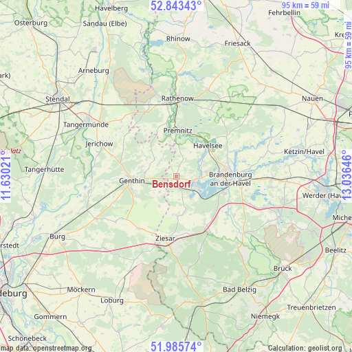
52° 25' 0.012" North, 12° 19' 59.988" East
| Map corner | latitude | longitude |
|---|---|---|
| Upper-left | 52.84343°, | 11.63021° |
| Center: | 52.41667°, | 12.33333° |
| Lower-right: | 51.98574°, | 13.03646° |
| Map W x H: | 95.4×95.4 km | = 59.3×59.3mi |
| max Lat: | 55.01917° ⇑23.6% North |
| Bensdorf: | 52.41667° |
| min Lat: | ⇓76.4% South 47.40724° |
| min Long | Bensdorf | max Long |
| 5.92978° | 12.33333° | 14.98853° |
| W 86.1%⇐ | ⇒13.9% E |
Elevation
Elevation of Bensdorf is 29 m = 95 ft, and this is 220.1 m = 722 ft below average elevation for this country.
| Max E: |
1256 m = 4121 ft | 87.3% |
| Avg. | 249.1 m = 817 ft | |
| Bensdorf | 29 m = 95 ft | |
Min E: |
-5 m = -16 ft | 12.7% |
See also: Germany elevation on elevation.city.
Geographical zone
Bensdorf is located in North temperate zone (between Tropic of Cancer and the Arctic Circle). Distance of this North polar circle is 1573 km =977.4 mi to North.| Distance of | km | miles | from Bensdorf |
|---|---|---|---|
| North Pole | 4178.9 | 2596.6 | to North |
| Arctic Circle | 1573 | 977.4 | to North |
| Tropic Cancer | 3222.3 | 2002.2 | to South |
| Equator | 5828.2 | 3621.5 | to South |


Nearby cities:
15 places around Bensdorf: (largest is in red/bold)
• Brandenburg an der Havel
14.7 km =9.1 mi,  90°
90°
• Brettin
10.3 km =6.4 mi,  276°
276°
• Genthin
11.9 km =7.4 mi,  264°
264°
• Kade
6.1 km =3.8 mi,  227°
227°
• Karow
9.3 km =5.8 mi,  210°
210°
• Mützel
11.5 km =7.1 mi,  248°
248°
• Premnitz
12.8 km =8 mi,  4°
4°
• Redekin
18.3 km =11.4 mi,  288°
288°
• Roßdorf
8.6 km =5.3 mi, 277°
• Schlagenthin
6.4 km =4 mi,  325°
325°
• Tucheim
17.4 km =10.8 mi,  215°
215°
• Wenzlow
15.2 km =9.4 mi,  148°
148°
• Wollin
17.4 km =10.8 mi, 148°
• Wusterwitz
6.6 km =4.1 mi, 147°
• Ziesar
17 km =10.6 mi,  189°
189°
Sources, notices
• [Note1] Compared only with cities in Germany existing in our database
• [Src1] Map data: © OpenStreetMap contributors (CC-BY-SA)
• [Src2] Other city data from geonames.org with taken over terms of usage.
• [Src3] Geographical zone / Annual Mean Temperature by Robert A. Rohde @ Wikipedia
