Lohra geodata
Lohra (Hesse) is a seat of a fourth-order administrative division; located in Germany in Europe/Berlin (GMT+2) time zone. With population of 5,775 people, there are 2534 cities with bigger population in this country. Compared to other cities in Germany, 52.8% of cities are located further ↓South; 69.8% of cities are located further →East and 52.7% of cities have higher elevation than Lohra. Note1
Administrative division(s):
- Level 1: Hesse
- Level 2: Regierungsbezirk Gießen
- Level 3: Landkreis Marburg-Biedenkopf
- Level 4: Lohra


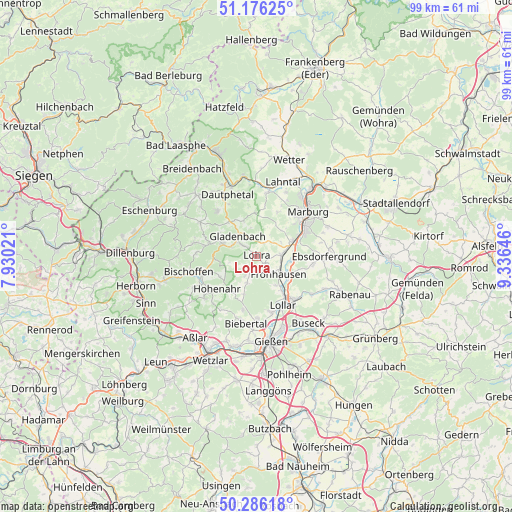
Lohra GPS coordinates[2]
50° 43' 59.988" North, 8° 37' 59.988" East
| Map corner | latitude | longitude |
|---|---|---|
| Upper-left | 51.17625°, | 7.93021° |
| Center: | 50.73333°, | 8.63333° |
| Lower-right: | 50.28618°, | 9.33646° |
| Map W x H: | 99×99 km | = 61.5×61.5mi |
| max Lat: | 55.01917° ⇑47.2% North |
| Lohra: | 50.73333° |
| min Lat: | ⇓52.8% South 47.40724° |
| min Long | Lohra | max Long |
| 5.92978° | 8.63333° | 14.98853° |
| W 30.2%⇐ | ⇒69.8% E |
Elevation
Elevation of Lohra is 206 m = 676 ft, and this is 43.1 m = 141 ft below average elevation for this country.
| Max E: |
1256 m = 4121 ft | 52.7% |
| Avg. | 249.1 m = 817 ft | |
| Lohra | 206 m = 676 ft | |
Min E: |
-5 m = -16 ft | 47.3% |
See also: Germany elevation on elevation.city.
Geographical zone
Lohra is located in North temperate zone (between Tropic of Cancer and the Arctic Circle). Distance of this North polar circle is 1760.2 km =1093.7 mi to North.| Distance of | km | miles | from Lohra |
|---|---|---|---|
| North Pole | 4366 | 2712.9 | to North |
| Arctic Circle | 1760.2 | 1093.7 | to North |
| Tropic Cancer | 3035.1 | 1885.9 | to South |
| Equator | 5641 | 3505.2 | to South |


Nearby cities:
15 places around Lohra: (largest is in red/bold)
• Alten Buseck
15 km =9.3 mi,  145°
145°
• Bad Endbach
9.6 km =6 mi,  281°
281°
• Bischoffen
13.4 km =8.3 mi,  253°
253°
• Cölbe
16.7 km =10.4 mi,  38°
38°
• Ebsdorfergrund
15.8 km =9.8 mi,  92°
92°
• Fronhausen
6 km =3.7 mi,  128°
128°
• Gießen
16.5 km =10.3 mi,  169°
169°
• Gladenbach
5.4 km =3.4 mi,  316°
316°
• Heuchelheim
16.7 km =10.4 mi,  180°
180°
• Lollar
10.9 km =6.8 mi, 152°
• Marburg an der Lahn
12.8 km =8 mi,  48°
48°
• Rabenau
17.4 km =10.8 mi,  110°
110°
• Siegbach
15.2 km =9.4 mi,  272°
272°
• Staufenberg
10.5 km =6.5 mi,  138°
138°
• Trohe
16.1 km =10 mi, 148°
Sources, notices
• [Note1] Compared only with cities in Germany existing in our database
• [Src1] Map data: © OpenStreetMap contributors (CC-BY-SA)
• [Src2] Other city data from geonames.org with taken over terms of usage.
• [Src3] Geographical zone / Annual Mean Temperature by Robert A. Rohde @ Wikipedia
