Bischoffen geodata
Bischoffen (Hesse) is a seat of a fourth-order administrative division; located in Germany in Europe/Berlin (GMT+2) time zone. With population of 3,478 people, there are 3628 cities with bigger population in this country. Compared to other cities in Germany, 52% of cities are located further ↓South; 71.5% of cities are located further →East and 58.7% of cities have lower elevation than Bischoffen. Note1
Administrative division(s):
- Level 1: Hesse
- Level 2: Regierungsbezirk Gießen
- Level 3: Lahn-Dill-Kreis
- Level 4: Bischoffen


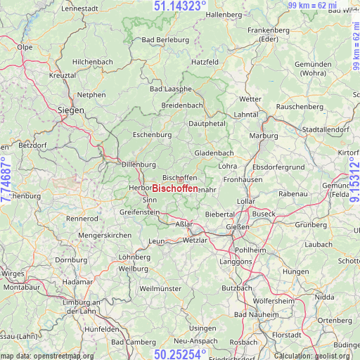
Bischoffen GPS coordinates[2]
50° 42' 0" North, 8° 27' 0" East
| Map corner | latitude | longitude |
|---|---|---|
| Upper-left | 51.14323°, | 7.74687° |
| Center: | 50.7°, | 8.45° |
| Lower-right: | 50.25254°, | 9.15312° |
| Map W x H: | 99×99 km | = 61.5×61.5mi |
| max Lat: | 55.01917° ⇑48% North |
| Bischoffen: | 50.7° |
| min Lat: | ⇓52% South 47.40724° |
| min Long | Bischoffen | max Long |
| 5.92978° | 8.45° | 14.98853° |
| W 28.5%⇐ | ⇒71.5% E |
Elevation
Elevation of Bischoffen is 282 m = 925 ft, and this is 32.9 m = 108 ft above average elevation for this country.
| Max E: |
1256 m = 4121 ft | 41.3% |
| Bischoffen | 282 m 925 ft | |
| Avg. | 249.1 m = 817 ft | |
Min E: |
-5 m = -16 ft | 58.7% |
See also: Germany elevation on elevation.city.
Geographical zone
Bischoffen is located in North temperate zone (between Tropic of Cancer and the Arctic Circle). Distance of this North polar circle is 1763.9 km =1096 mi to North.| Distance of | km | miles | from Bischoffen |
|---|---|---|---|
| North Pole | 4369.8 | 2715.3 | to North |
| Arctic Circle | 1763.9 | 1096 | to North |
| Tropic Cancer | 3031.4 | 1883.6 | to South |
| Equator | 5637.3 | 3502.9 | to South |


Nearby cities:
15 places around Bischoffen: (largest is in red/bold)
• Aßlar
12.1 km =7.5 mi,  175°
175°
• Bad Endbach
6.6 km =4.1 mi,  32°
32°
• Dillenburg
12.4 km =7.7 mi,  291°
291°
• Ehringshausen
12.1 km =7.5 mi,  202°
202°
• Gladenbach
11.9 km =7.4 mi,  50°
50°
• Greifenstein
14.1 km =8.8 mi,  228°
228°
• Herborn
10.5 km =6.5 mi,  258°
258°
• Lohra
13.4 km =8.3 mi,  73°
73°
• Merkenbach
11.9 km =7.4 mi,  245°
245°
• Mittenaar
4.7 km =2.9 mi,  270°
270°
• Niederbiel
16.5 km =10.3 mi,  192°
192°
• Oberbiel
16.4 km =10.2 mi, 185°
• Siegbach
4.9 km =3 mi,  332°
332°
• Sinn
9.9 km =6.2 mi,  235°
235°
• Wetzlar
15.9 km =9.9 mi,  165°
165°
Sources, notices
• [Note1] Compared only with cities in Germany existing in our database
• [Src1] Map data: © OpenStreetMap contributors (CC-BY-SA)
• [Src2] Other city data from geonames.org with taken over terms of usage.
• [Src3] Geographical zone / Annual Mean Temperature by Robert A. Rohde @ Wikipedia
