Bad Endbach geodata
Bad Endbach (Hesse) is a seat of a fourth-order administrative division; located in Germany in Europe/Berlin (GMT+2) time zone. With population of 8,734 people, there are 1837 cities with bigger population in this country. Compared to other cities in Germany, 53.2% of cities are located further ↓South; 71.1% of cities are located further →East and 70.1% of cities have lower elevation than Bad Endbach. Note1
Administrative division(s):
- Level 1: Hesse
- Level 2: Regierungsbezirk Gießen
- Level 3: Landkreis Marburg-Biedenkopf
- Level 4: Bad Endbach


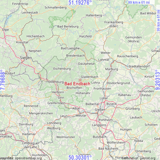
Bad Endbach GPS coordinates[2]
50° 45' 0" North, 8° 30' 0" East
| Map corner | latitude | longitude |
|---|---|---|
| Upper-left | 51.19276°, | 7.79688° |
| Center: | 50.75°, | 8.5° |
| Lower-right: | 50.30301°, | 9.20313° |
| Map W x H: | 98.9×98.9 km | = 61.5×61.5mi |
| max Lat: | 55.01917° ⇑46.8% North |
| Bad Endbach: | 50.75° |
| min Lat: | ⇓53.2% South 47.40724° |
| min Long | Bad Endbach | max Long |
| 5.92978° | 8.5° | 14.98853° |
| W 28.9%⇐ | ⇒71.1% E |
Elevation
Elevation of Bad Endbach is 359 m = 1178 ft, and this is 109.9 m = 361 ft above average elevation for this country.
| Max E: |
1256 m = 4121 ft | 29.9% |
| Bad Endbach | 359 m 1178 ft | |
| Avg. | 249.1 m = 817 ft | |
Min E: |
-5 m = -16 ft | 70.1% |
See also: Germany elevation on elevation.city.
Geographical zone
Bad Endbach is located in North temperate zone (between Tropic of Cancer and the Arctic Circle). Distance of this North polar circle is 1758.3 km =1092.6 mi to North.| Distance of | km | miles | from Bad Endbach |
|---|---|---|---|
| North Pole | 4364.2 | 2711.8 | to North |
| Arctic Circle | 1758.3 | 1092.6 | to North |
| Tropic Cancer | 3037 | 1887.1 | to South |
| Equator | 5642.9 | 3506.3 | to South |


Nearby cities:
15 places around Bad Endbach: (largest is in red/bold)
• Aßlar
17.8 km =11.1 mi,  188°
188°
• Biedenkopf
18.1 km =11.2 mi,  6°
6°
• Bischoffen
6.6 km =4.1 mi,  212°
212°
• Breidenbach
15.6 km =9.7 mi,  348°
348°
• Dillenburg
15 km =9.3 mi,  266°
266°
• Ehringshausen
18.6 km =11.6 mi, 206°
• Fronhausen
15.1 km =9.4 mi,  111°
111°
• Gladenbach
6 km =3.7 mi,  70°
70°
• Herborn
15.8 km =9.8 mi,  241°
241°
• Lohra
9.6 km =6 mi,  101°
101°
• Lollar
18.5 km =11.5 mi,  128°
128°
• Merkenbach
17.8 km =11.1 mi,  234°
234°
• Mittenaar
9.9 km =6.2 mi, 235°
• Siegbach
5.9 km =3.7 mi,  257°
257°
• Sinn
16.2 km =10.1 mi, 226°
Sources, notices
• [Note1] Compared only with cities in Germany existing in our database
• [Src1] Map data: © OpenStreetMap contributors (CC-BY-SA)
• [Src2] Other city data from geonames.org with taken over terms of usage.
• [Src3] Geographical zone / Annual Mean Temperature by Robert A. Rohde @ Wikipedia
