Teningen geodata
Teningen (Baden-Württemberg) is a seat of a fourth-order administrative division; located in Germany in Europe/Berlin (GMT+2) time zone. With population of 11,887 people, there are 1380 cities with bigger population in this country. Compared to other cities in Germany, 93.7% of cities are located further ↑North; 80.8% of cities are located further →East and 54.9% of cities have higher elevation than Teningen. Note1
Administrative division(s):
- Level 1: Baden-Württemberg
- Level 2: Freiburg Region
- Level 3: Landkreis Emmendingen
- Level 4: Teningen


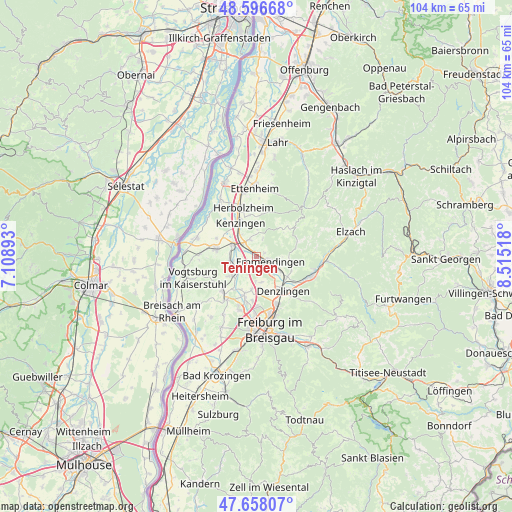
Teningen GPS coordinates[2]
48° 7' 46.272" North, 7° 48' 43.38" East
| Map corner | latitude | longitude |
|---|---|---|
| Upper-left | 48.59668°, | 7.10893° |
| Center: | 48.12952°, | 7.81205° |
| Lower-right: | 47.65807°, | 8.51518° |
| Map W x H: | 104.4×104.4 km | = 64.9×64.9mi |
| max Lat: | 55.01917° ⇑93.7% North |
| Teningen: | 48.12952° |
| min Lat: | ⇓6.3% South 47.40724° |
| min Long | Teningen | max Long |
| 5.92978° | 7.81205° | 14.98853° |
| W 19.2%⇐ | ⇒80.8% E |
Elevation
Elevation of Teningen is 190 m = 623 ft, and this is 59.1 m = 194 ft below average elevation for this country.
| Max E: |
1256 m = 4121 ft | 54.9% |
| Avg. | 249.1 m = 817 ft | |
| Teningen | 190 m = 623 ft | |
Min E: |
-5 m = -16 ft | 45.1% |
See also: Germany elevation on elevation.city.
Geographical zone
Teningen is located in North temperate zone (between Tropic of Cancer and the Arctic Circle). Distance of this North polar circle is 2049.7 km =1273.6 mi to North.| Distance of | km | miles | from Teningen |
|---|---|---|---|
| North Pole | 4655.6 | 2892.9 | to North |
| Arctic Circle | 2049.7 | 1273.6 | to North |
| Tropic Cancer | 2745.6 | 1706 | to South |
| Equator | 5351.5 | 3325.3 | to South |


Nearby cities:
15 places around Teningen: (largest is in red/bold)
• Bahlingen
5.5 km =3.4 mi,  259°
259°
• Buchheim
8.3 km =5.2 mi,  200°
200°
• Bötzingen
8.8 km =5.5 mi,  227°
227°
• Denzlingen
8.8 km =5.5 mi,  142°
142°
• Eichstetten
6.5 km =4 mi, 232°
• Emmendingen
3.2 km =2 mi,  107°
107°
• Endingen
8.4 km =5.2 mi,  279°
279°
• Forchheim
9.3 km =5.8 mi,  296°
296°
• Gundelfingen
10.5 km =6.5 mi,  157°
157°
• Herbolzheim
10.3 km =6.4 mi,  345°
345°
• Kenzingen
8.1 km =5 mi,  337°
337°
• Malterdingen
3.6 km =2.2 mi,  327°
327°
• Riegel
5.2 km =3.2 mi, 297°
• Sexau
7.7 km =4.8 mi, 113°
• Vörstetten
7.5 km =4.7 mi, 158°
Sources, notices
• [Note1] Compared only with cities in Germany existing in our database
• [Src1] Map data: © OpenStreetMap contributors (CC-BY-SA)
• [Src2] Other city data from geonames.org with taken over terms of usage.
• [Src3] Geographical zone / Annual Mean Temperature by Robert A. Rohde @ Wikipedia
